Faveraye-Mâchelles geodata
Faveraye-Mâchelles (Pays de la Loire) is a populated place; located in France in Europe/Paris (GMT+2) time zone. With population of 523 people, there are 14759 cities with bigger population in this country. Compared to other cities in France, 52.3% of cities are located further ↑North; 83.4% of cities are located further →East and 86.7% of cities have higher elevation than Faveraye-Mâchelles. Note1
Administrative division(s):
- Level 1: Pays de la Loire
- Level 2: Département de Maine-et-Loire
- Level 3: Angers
- Level 4: Bellevigne-en-Layon


Faveraye-Mâchelles GPS coordinates[2]
47° 15' 0" North, 0° 30' 0" West
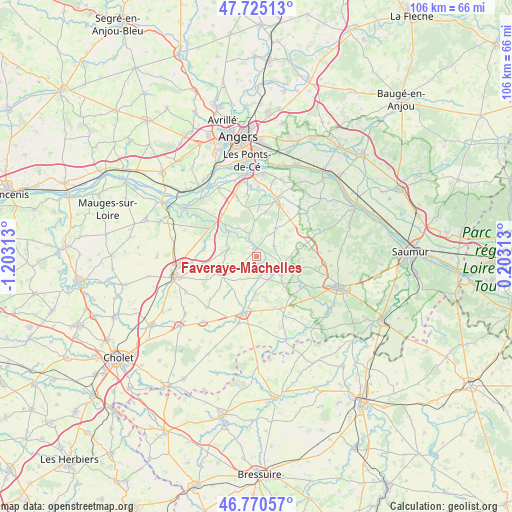
| Map corner | latitude | longitude |
|---|---|---|
| Upper-left | 47.72513°, | -1.20313° |
| Center: | 47.25°, | -0.5° |
| Lower-right: | 46.77057°, | 0.20313° |
| Map W x H: | 106.1×106.1 km | = 65.9×65.9mi |
| max Lat: | 51.07786° ⇑52.3% North |
| Faveraye-Mâchelles: | 47.25° |
| min Lat: | ⇓47.7% South 41.3874° |
| min Long | Faveraye-Mâche | max Long |
| -5.08615° | -0.5° | 9.52242° |
| W 16.6%⇐ | ⇒83.4% E |
Elevation
Elevation of Faveraye-Mâchelles is 38 m = 125 ft, and this is 155.7 m = 511 ft below average elevation for this country.
| Max E: |
2333 m = 7654 ft | 86.7% |
| Avg. | 193.7 m = 635 ft | |
| Faveraye-Mâchelles | 38 m = 125 ft | |
Min E: |
-1 m = -3 ft | 13.3% |
See also: France elevation on elevation.city.
Geographical zone
Faveraye-Mâchelles is located in North temperate zone (between Tropic of Cancer and the Arctic Circle). Distance of this North polar circle is 2147.5 km =1334.4 mi to North.| Distance of | km | miles | from Faveraye-Mâchelles |
|---|---|---|---|
| North Pole | 4753.4 | 2953.6 | to North |
| Arctic Circle | 2147.5 | 1334.4 | to North |
| Tropic Cancer | 2647.8 | 1645.3 | to South |
| Equator | 5253.7 | 3264.5 | to South |


Nearby cities:
15 places around Faveraye-Mâchelles: (largest is in red/bold)
• Ambillou-Château
11.8 km =7.3 mi,  83°
83°
• Beaulieu-sur-Layon
9.6 km =6 mi,  314°
314°
• Brissac-Quincé
12.4 km =7.7 mi,  18°
18°
• Chanzeaux
10.9 km =6.8 mi,  277°
277°
• Chavagnes
4.1 km =2.5 mi,  57°
57°
• Les Alleuds
10.3 km =6.4 mi,  42°
42°
• Martigné-Briand
5.6 km =3.5 mi,  108°
108°
• Rablay-sur-Layon
7.6 km =4.7 mi, 310°
• Saint-Georges-sur-Layon
11.6 km =7.2 mi,  120°
120°
• Saint-Jean
8.8 km =5.5 mi,  93°
93°
• Saint-Lambert-du-Lattay
11.6 km =7.2 mi,  300°
300°
• Thouarcé
1.9 km =1.2 mi,  355°
355°
• Tigné
7.8 km =4.8 mi,  135°
135°
• Vauchrétien
9.3 km =5.8 mi,  10°
10°
• Vihiers
11.8 km =7.3 mi,  191°
191°
Sources, notices
• [Note1] Compared only with cities in France existing in our database
• [Src1] Map data: © OpenStreetMap contributors (CC-BY-SA)
• [Src2] Other city data from geonames.org with taken over terms of usage.
• [Src3] Geographical zone / Annual Mean Temperature by Robert A. Rohde @ Wikipedia
