Garlin geodata
Garlin (Nouvelle-Aquitaine) is a populated place; located in France in Europe/Paris (GMT+2) time zone. With population of 1,251 people, there are 7273 cities with bigger population in this country. Compared to other cities in France, 92.3% of cities are located further ↑North; 80.6% of cities are located further →East and 67.4% of cities have lower elevation than Garlin. Note1
Administrative division(s):
- Level 1: Nouvelle-Aquitaine
- Level 2: Département des Pyrénées-Atlantiques
- Level 3: Arrondissement de Pau
- Level 4: Garlin


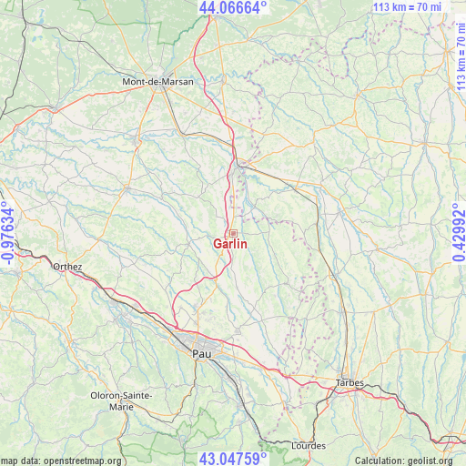
Garlin GPS coordinates[2]
43° 33' 33.372" North, 0° 16' 23.556" West
| Map corner | latitude | longitude |
|---|---|---|
| Upper-left | 44.06664°, | -0.97634° |
| Center: | 43.55927°, | -0.27321° |
| Lower-right: | 43.04759°, | 0.42992° |
| Map W x H: | 113.3×113.3 km | = 70.4×70.4mi |
| max Lat: | 51.07786° ⇑92.3% North |
| Garlin: | 43.55927° |
| min Lat: | ⇓7.7% South 41.3874° |
| min Long | Garlin | max Long |
| -5.08615° | -0.27321° | 9.52242° |
| W 19.4%⇐ | ⇒80.6% E |
Elevation
Elevation of Garlin is 206 m = 676 ft, and this is 12.3 m = 40 ft above average elevation for this country.
| Max E: |
2333 m = 7654 ft | 32.6% |
| Garlin | 206 m 676 ft | |
| Avg. | 193.7 m = 635 ft | |
Min E: |
-1 m = -3 ft | 67.4% |
See also: France elevation on elevation.city.
Geographical zone
Garlin is located in North temperate zone (between Tropic of Cancer and the Arctic Circle). Distance of this Northern Tropic circle is 2237.4 km =1390.3 mi to South.| Distance of | km | miles | from Garlin |
|---|---|---|---|
| North Pole | 5163.7 | 3208.6 | to North |
| Arctic Circle | 2557.8 | 1589.3 | to North |
| Tropic Cancer | 2237.4 | 1390.3 | to South |
| Equator | 4843.3 | 3009.5 | to South |


Nearby cities:
15 places around Garlin: (largest is in red/bold)
• Arzacq-Arraziguet
11.9 km =7.4 mi,  255°
255°
• Barcelonne-du-Gers
16.3 km =10.1 mi,  10°
10°
• Barinque
17.7 km =11 mi,  178°
178°
• Duhort-Bachen
18.7 km =11.6 mi,  347°
347°
• Eugénie-les-Bains
17.4 km =10.8 mi,  330°
330°
• Geaune
12.4 km =7.7 mi,  316°
316°
• Lembeye
18.5 km =11.5 mi,  131°
131°
• Madiran
18 km =11.2 mi,  93°
93°
• Navailles-Angos
16.6 km =10.3 mi,  197°
197°
• Riscle
18.5 km =11.5 mi,  54°
54°
• Saint-Armou
16 km =9.9 mi,  187°
187°
• Sainte-Marie-de-Gosse
3.4 km =2.1 mi,  107°
107°
• Sévignacq
12.2 km =7.6 mi, 177°
• Thèze
10.5 km =6.5 mi,  216°
216°
• Viella
11.7 km =7.3 mi,  67°
67°
Sources, notices
• [Note1] Compared only with cities in France existing in our database
• [Src1] Map data: © OpenStreetMap contributors (CC-BY-SA)
• [Src2] Other city data from geonames.org with taken over terms of usage.
• [Src3] Geographical zone / Annual Mean Temperature by Robert A. Rohde @ Wikipedia
