Saint-Raphaël geodata
Saint-Raphaël (Provence-Alpes-Côte d'Azur) is a populated place; located in France in Europe/Paris (GMT+2) time zone. With population of 34,918 people, there are 222 cities with bigger population in this country. Compared to other cities in France, 94% of cities are located further ↑North; 93.5% of cities are located further ←West and 93.1% of cities have higher elevation than Saint-Raphaël. Note1
Administrative division(s):
- Level 1: Provence-Alpes-Côte d'Azur
- Level 2: Var
- Level 3: Arrondissement de Draguignan
- Level 4: Saint-Raphaël


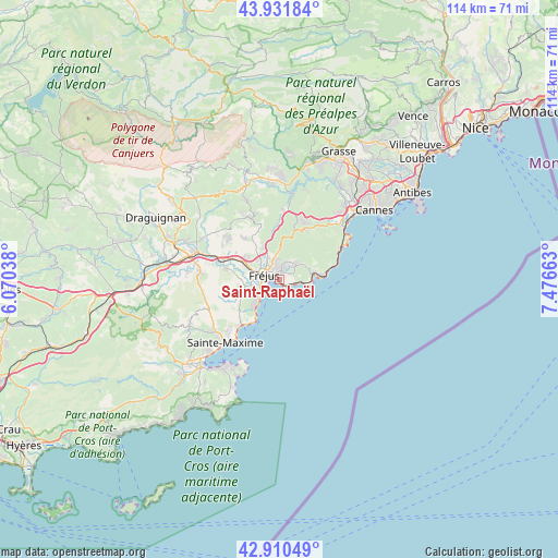
Saint-Raphaël GPS coordinates[2]
43° 25' 23.952" North, 6° 46' 24.6" East
| Map corner | latitude | longitude |
|---|---|---|
| Upper-left | 43.93184°, | 6.07038° |
| Center: | 43.42332°, | 6.7735° |
| Lower-right: | 42.91049°, | 7.47663° |
| Map W x H: | 113.6×113.6 km | = 70.6×70.6mi |
| max Lat: | 51.07786° ⇑94% North |
| Saint-Raphaël: | 43.42332° |
| min Lat: | ⇓6% South 41.3874° |
| min Long | Saint-Raphaël | max Long |
| -5.08615° | 6.7735° | 9.52242° |
| W 93.5%⇐ | ⇒6.5% E |
Elevation
Elevation of Saint-Raphaël is 22 m = 72 ft, and this is 171.7 m = 563 ft below average elevation for this country.
| Max E: |
2333 m = 7654 ft | 93.1% |
| Avg. | 193.7 m = 635 ft | |
| Saint-Raphaël | 22 m = 72 ft | |
Min E: |
-1 m = -3 ft | 6.9% |
See also: France elevation on elevation.city.
Geographical zone
Saint-Raphaël is located in North temperate zone (between Tropic of Cancer and the Arctic Circle). Distance of this Northern Tropic circle is 2222.3 km =1380.9 mi to South.| Distance of | km | miles | from Saint-Raphaël |
|---|---|---|---|
| North Pole | 5178.8 | 3218 | to North |
| Arctic Circle | 2573 | 1598.8 | to North |
| Tropic Cancer | 2222.3 | 1380.9 | to South |
| Equator | 4828.2 | 3000.1 | to South |


Nearby cities:
15 places around Saint-Raphaël: (largest is in red/bold)
• Bagnols-en-Forêt
14.1 km =8.8 mi,  334°
334°
• Callian
22.2 km =13.8 mi,  355°
355°
• Fréjus
3.3 km =2.1 mi,  289°
289°
• La Motte
20.8 km =12.9 mi, 292°
• Le Muy
17.6 km =10.9 mi, 288°
• Le Plan-de-la-Tour
20.6 km =12.8 mi,  241°
241°
• Mandelieu-la-Napoule
19 km =11.8 mi,  44°
44°
• Montauroux
21.7 km =13.5 mi, 358°
• Puget-sur-Argens
8 km =5 mi,  296°
296°
• Roquebrune-sur-Argens
11.2 km =7 mi,  281°
281°
• Saint-Paul-en-Forêt
17.3 km =10.7 mi,  337°
337°
• Saint-Tropez
20.4 km =12.7 mi,  211°
211°
• Sainte-Maxime
16.7 km =10.4 mi,  220°
220°
• Tanneron
20.3 km =12.6 mi,  23°
23°
• Théoule-sur-Mer
16.4 km =10.2 mi,  55°
55°
Sources, notices
• [Note1] Compared only with cities in France existing in our database
• [Src1] Map data: © OpenStreetMap contributors (CC-BY-SA)
• [Src2] Other city data from geonames.org with taken over terms of usage.
• [Src3] Geographical zone / Annual Mean Temperature by Robert A. Rohde @ Wikipedia
