Thenon geodata
Thenon (Nouvelle-Aquitaine) is a populated place; located in France in Europe/Paris (GMT+2) time zone. With population of 1,278 people, there are 7134 cities with bigger population in this country. Compared to other cities in France, 78.1% of cities are located further ↑North; 68.1% of cities are located further →East and 76.5% of cities have lower elevation than Thenon. Note1
Administrative division(s):
- Level 1: Nouvelle-Aquitaine
- Level 2: Dordogne
- Level 3: Arrondissement de Sarlat-la-Canéda
- Level 4: Thenon


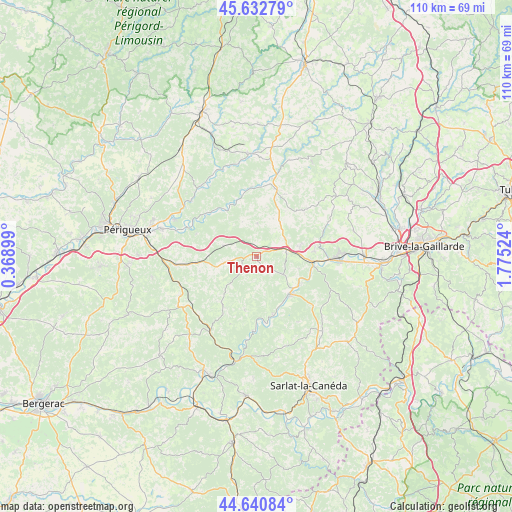
Thenon GPS coordinates[2]
45° 8' 20.292" North, 1° 4' 19.596" East
| Map corner | latitude | longitude |
|---|---|---|
| Upper-left | 45.63279°, | 0.36899° |
| Center: | 45.13897°, | 1.07211° |
| Lower-right: | 44.64084°, | 1.77524° |
| Map W x H: | 110.3×110.3 km | = 68.5×68.5mi |
| max Lat: | 51.07786° ⇑78.1% North |
| Thenon: | 45.13897° |
| min Lat: | ⇓21.9% South 41.3874° |
| min Long | Thenon | max Long |
| -5.08615° | 1.07211° | 9.52242° |
| W 31.9%⇐ | ⇒68.1% E |
Elevation
Elevation of Thenon is 260 m = 853 ft, and this is 66.3 m = 218 ft above average elevation for this country.
| Max E: |
2333 m = 7654 ft | 23.5% |
| Thenon | 260 m 853 ft | |
| Avg. | 193.7 m = 635 ft | |
Min E: |
-1 m = -3 ft | 76.5% |
See also: France elevation on elevation.city.
Geographical zone
Thenon is located in North temperate zone (between Tropic of Cancer and the Arctic Circle). Distance of this North polar circle is 2382.2 km =1480.2 mi to North.| Distance of | km | miles | from Thenon |
|---|---|---|---|
| North Pole | 4988.1 | 3099.5 | to North |
| Arctic Circle | 2382.2 | 1480.2 | to North |
| Tropic Cancer | 2413.1 | 1499.4 | to South |
| Equator | 5019 | 3118.7 | to South |


Nearby cities:
15 places around Thenon: (largest is in red/bold)
• Aubas
11.4 km =7.1 mi,  123°
123°
• Beauregard-de-Terrasson
12.4 km =7.7 mi,  85°
85°
• Cherveix-Cubas
17.1 km =10.6 mi,  11°
11°
• Condat-sur-Vézère
12.8 km =8 mi,  100°
100°
• Cubjac
14 km =8.7 mi,  311°
311°
• Fossemagne
6.9 km =4.3 mi,  259°
259°
• Hautefort
14.7 km =9.1 mi,  24°
24°
• Le Change
15.3 km =9.5 mi,  294°
294°
• Le Lardin-Saint-Lazare
11.4 km =7.1 mi, 93°
• Montignac
10.9 km =6.8 mi,  139°
139°
• Plazac
11.8 km =7.3 mi,  192°
192°
• Rouffignac-Saint-Cernin-de-Reilhac
12.9 km =8 mi,  219°
219°
• Saint-Pierre-de-Chignac
17 km =10.6 mi, 264°
• Saint-Rabier
7.2 km =4.5 mi,  59°
59°
• Tourtoirac
14.6 km =9.1 mi,  355°
355°
Sources, notices
• [Note1] Compared only with cities in France existing in our database
• [Src1] Map data: © OpenStreetMap contributors (CC-BY-SA)
• [Src2] Other city data from geonames.org with taken over terms of usage.
• [Src3] Geographical zone / Annual Mean Temperature by Robert A. Rohde @ Wikipedia
