Fossemagne geodata
Fossemagne (Nouvelle-Aquitaine) is a populated place; located in France in Europe/Paris (GMT+2) time zone. With population of 555 people, there are 14118 cities with bigger population in this country. Compared to other cities in France, 78.2% of cities are located further ↑North; 68.9% of cities are located further →East and 68.5% of cities have lower elevation than Fossemagne. Note1
Administrative division(s):
- Level 1: Nouvelle-Aquitaine
- Level 2: Dordogne
- Level 3: Arrondissement de Sarlat-la-Canéda
- Level 4: Fossemagne


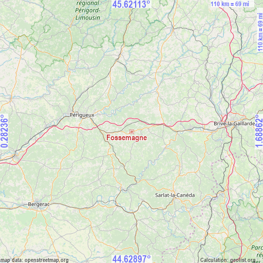
Fossemagne GPS coordinates[2]
45° 7' 37.956" North, 0° 59' 7.764" East
| Map corner | latitude | longitude |
|---|---|---|
| Upper-left | 45.62113°, | 0.28236° |
| Center: | 45.12721°, | 0.98549° |
| Lower-right: | 44.62897°, | 1.68862° |
| Map W x H: | 110.3×110.3 km | = 68.5×68.5mi |
| max Lat: | 51.07786° ⇑78.2% North |
| Fossemagne: | 45.12721° |
| min Lat: | ⇓21.8% South 41.3874° |
| min Long | Fossemagne | max Long |
| -5.08615° | 0.98549° | 9.52242° |
| W 31.1%⇐ | ⇒68.9% E |
Elevation
Elevation of Fossemagne is 211 m = 692 ft, and this is 17.3 m = 57 ft above average elevation for this country.
| Max E: |
2333 m = 7654 ft | 31.5% |
| Fossemagne | 211 m 692 ft | |
| Avg. | 193.7 m = 635 ft | |
Min E: |
-1 m = -3 ft | 68.5% |
See also: France elevation on elevation.city.
Geographical zone
Fossemagne is located in North temperate zone (between Tropic of Cancer and the Arctic Circle). Distance of this North polar circle is 2383.5 km =1481 mi to North.| Distance of | km | miles | from Fossemagne |
|---|---|---|---|
| North Pole | 4989.4 | 3100.3 | to North |
| Arctic Circle | 2383.5 | 1481 | to North |
| Tropic Cancer | 2411.8 | 1498.6 | to South |
| Equator | 5017.7 | 3117.9 | to South |


Nearby cities:
15 places around Fossemagne: (largest is in red/bold)
• Antonne-et-Trigonant
15.5 km =9.6 mi,  307°
307°
• Bassillac
15.2 km =9.4 mi,  298°
298°
• Cubjac
11.2 km =7 mi,  341°
341°
• Eyliac
10.9 km =6.8 mi,  290°
290°
• La Douze
11.9 km =7.4 mi,  232°
232°
• Lacropte
15.8 km =9.8 mi, 230°
• Le Change
10.5 km =6.5 mi,  317°
317°
• Marsaneix
16.1 km =10 mi,  258°
258°
• Montignac
15.5 km =9.6 mi,  116°
116°
• Plazac
11.1 km =6.9 mi,  157°
157°
• Rouffignac-Saint-Cernin-de-Reilhac
8.7 km =5.4 mi,  189°
189°
• Saint-Laurent-sur-Manoire
15.1 km =9.4 mi,  278°
278°
• Saint-Pierre-de-Chignac
10.2 km =6.3 mi,  267°
267°
• Saint-Rabier
13.9 km =8.6 mi,  68°
68°
• Thenon
6.9 km =4.3 mi,  79°
79°
Sources, notices
• [Note1] Compared only with cities in France existing in our database
• [Src1] Map data: © OpenStreetMap contributors (CC-BY-SA)
• [Src2] Other city data from geonames.org with taken over terms of usage.
• [Src3] Geographical zone / Annual Mean Temperature by Robert A. Rohde @ Wikipedia
