Condat-sur-Vézère geodata
Condat-sur-Vézère (Nouvelle-Aquitaine) is a populated place; located in France in Europe/Paris (GMT+2) time zone. With population of 882 people, there are 9803 cities with bigger population in this country. Compared to other cities in France, 78.3% of cities are located further ↑North; 66.3% of cities are located further →East and 66.6% of cities have higher elevation than Condat-sur-Vézère. Note1
Administrative division(s):
- Level 1: Nouvelle-Aquitaine
- Level 2: Dordogne
- Level 3: Arrondissement de Sarlat-la-Canéda
- Level 4: Condat-sur-Vézère


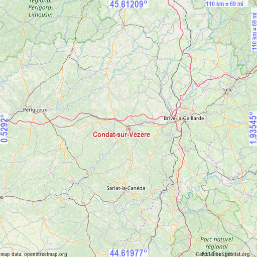
Condat-sur-Vézère GPS coordinates[2]
45° 7' 5.124" North, 1° 13' 56.388" East
| Map corner | latitude | longitude |
|---|---|---|
| Upper-left | 45.61209°, | 0.5292° |
| Center: | 45.11809°, | 1.23233° |
| Lower-right: | 44.61977°, | 1.93545° |
| Map W x H: | 110.3×110.3 km | = 68.5×68.5mi |
| max Lat: | 51.07786° ⇑78.3% North |
| Condat-sur-Vézère: | 45.11809° |
| min Lat: | ⇓21.7% South 41.3874° |
| min Long | Condat-sur-Véz | max Long |
| -5.08615° | 1.23233° | 9.52242° |
| W 33.7%⇐ | ⇒66.3% E |
Elevation
Elevation of Condat-sur-Vézère is 86 m = 282 ft, and this is 107.7 m = 353 ft below average elevation for this country.
| Max E: |
2333 m = 7654 ft | 66.6% |
| Avg. | 193.7 m = 635 ft | |
| Condat-sur-Vézère | 86 m = 282 ft | |
Min E: |
-1 m = -3 ft | 33.4% |
See also: France elevation on elevation.city.
Geographical zone
Condat-sur-Vézère is located in North temperate zone (between Tropic of Cancer and the Arctic Circle). Distance of this North polar circle is 2384.5 km =1481.7 mi to North.| Distance of | km | miles | from Condat-sur-Vézère |
|---|---|---|---|
| North Pole | 4990.4 | 3100.9 | to North |
| Arctic Circle | 2384.5 | 1481.7 | to North |
| Tropic Cancer | 2410.7 | 1497.9 | to South |
| Equator | 5016.7 | 3117.2 | to South |


Nearby cities:
15 places around Condat-sur-Vézère: (largest is in red/bold)
• Aubas
5.1 km =3.2 mi,  217°
217°
• Ayen
16.1 km =10 mi,  27°
27°
• Beauregard-de-Terrasson
3.4 km =2.1 mi,  356°
356°
• Brignac-la-Plaine
11.5 km =7.1 mi,  46°
46°
• Cublac
6.5 km =4 mi,  62°
62°
• Larche
14.4 km =8.9 mi,  88°
88°
• Le Lardin-Saint-Lazare
2.1 km =1.3 mi,  324°
324°
• Mansac
13.1 km =8.1 mi, 64°
• Montignac
8.1 km =5 mi, 222°
• Pazayac
11.5 km =7.1 mi, 87°
• Saint-Geniès
13.2 km =8.2 mi,  173°
173°
• Saint-Rabier
8.8 km =5.5 mi,  313°
313°
• Terrasson-Lavilledieu
5.6 km =3.5 mi,  76°
76°
• Thenon
12.8 km =8 mi,  280°
280°
• Yssandon
15.1 km =9.4 mi, 48°
Sources, notices
• [Note1] Compared only with cities in France existing in our database
• [Src1] Map data: © OpenStreetMap contributors (CC-BY-SA)
• [Src2] Other city data from geonames.org with taken over terms of usage.
• [Src3] Geographical zone / Annual Mean Temperature by Robert A. Rohde @ Wikipedia
