Teurthéville-Bocage geodata
Teurthéville-Bocage (Normandy) is a populated place; located in France in Europe/Paris (GMT+2) time zone. With population of 571 people, there are 13815 cities with bigger population in this country. Compared to other cities in France, 90.5% of cities are located further ↓South; 91.5% of cities are located further →East and 71.4% of cities have higher elevation than Teurthéville-Bocage. Note1
Administrative division(s):
- Level 1: Normandy
- Level 2: Manche
- Level 3: Arrondissement de Cherbourg
- Level 4: Teurthéville-Bocage


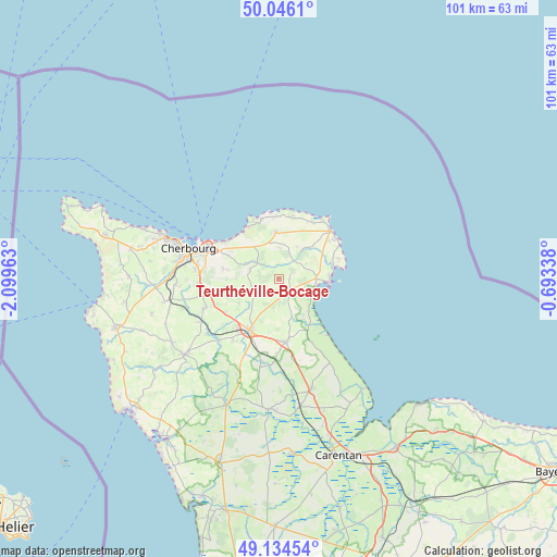
Teurthéville-Bocage GPS coordinates[2]
49° 35' 32.82" North, 1° 23' 47.4" West
| Map corner | latitude | longitude |
|---|---|---|
| Upper-left | 50.0461°, | -2.09963° |
| Center: | 49.59245°, | -1.3965° |
| Lower-right: | 49.13454°, | -0.69338° |
| Map W x H: | 101.4×101.4 km | = 63×63mi |
| max Lat: | 51.07786° ⇑9.5% North |
| Teurthéville-Bocage: | 49.59245° |
| min Lat: | ⇓90.5% South 41.3874° |
| min Long | Teurthéville-B | max Long |
| -5.08615° | -1.3965° | 9.52242° |
| W 8.5%⇐ | ⇒91.5% E |
Elevation
Elevation of Teurthéville-Bocage is 75 m = 246 ft, and this is 118.7 m = 389 ft below average elevation for this country.
| Max E: |
2333 m = 7654 ft | 71.4% |
| Avg. | 193.7 m = 635 ft | |
| Teurthéville-Bocage | 75 m = 246 ft | |
Min E: |
-1 m = -3 ft | 28.6% |
See also: France elevation on elevation.city.
Geographical zone
Teurthéville-Bocage is located in North temperate zone (between Tropic of Cancer and the Arctic Circle). Distance of this North polar circle is 1887 km =1172.5 mi to North.| Distance of | km | miles | from Teurthéville-Bocage |
|---|---|---|---|
| North Pole | 4492.9 | 2791.8 | to North |
| Arctic Circle | 1887 | 1172.5 | to North |
| Tropic Cancer | 2908.2 | 1807.1 | to South |
| Equator | 5514.2 | 3426.4 | to South |


Nearby cities:
15 places around Teurthéville-Bocage: (largest is in red/bold)
• Cosqueville
11.3 km =7 mi,  355°
355°
• Digosville
10.3 km =6.4 mi,  294°
294°
• Fermanville
11.5 km =7.1 mi,  335°
335°
• Gonneville
7.3 km =4.5 mi,  317°
317°
• Le Mesnil-au-Val
9.4 km =5.8 mi,  279°
279°
• Le Theil
5.7 km =3.5 mi, 290°
• Montebourg
11.7 km =7.3 mi,  174°
174°
• Montfarville
11.4 km =7.1 mi,  52°
52°
• Quettehou
6.7 km =4.2 mi,  89°
89°
• Réville
10.4 km =6.5 mi,  73°
73°
• Saint-Pierre-Église
8.5 km =5.3 mi, 356°
• Saint-Vaast-la-Hougue
9.2 km =5.7 mi, 92°
• Saussemesnil
5.2 km =3.2 mi,  246°
246°
• Tamerville
7.8 km =4.8 mi,  211°
211°
• Valognes
10.7 km =6.6 mi, 209°
Sources, notices
• [Note1] Compared only with cities in France existing in our database
• [Src1] Map data: © OpenStreetMap contributors (CC-BY-SA)
• [Src2] Other city data from geonames.org with taken over terms of usage.
• [Src3] Geographical zone / Annual Mean Temperature by Robert A. Rohde @ Wikipedia
