Cosqueville geodata
Cosqueville (Normandy) is a populated place; located in France in Europe/Paris (GMT+2) time zone. With population of 501 people, there are 15224 cities with bigger population in this country. Compared to other cities in France, 91.5% of cities are located further ↓South; 91.6% of cities are located further →East and 91.6% of cities have higher elevation than Cosqueville. Note1
Administrative division(s):
- Level 1: Normandy
- Level 2: Manche
- Level 3: Arrondissement de Cherbourg
- Level 4: Vicq-sur-Mer


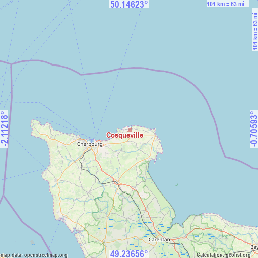
Cosqueville GPS coordinates[2]
49° 41' 36.672" North, 1° 24' 32.58" West
| Map corner | latitude | longitude |
|---|---|---|
| Upper-left | 50.14623°, | -2.11218° |
| Center: | 49.69352°, | -1.40905° |
| Lower-right: | 49.23656°, | -0.70593° |
| Map W x H: | 101.1×101.1 km | = 62.8×62.8mi |
| max Lat: | 51.07786° ⇑8.5% North |
| Cosqueville: | 49.69352° |
| min Lat: | ⇓91.5% South 41.3874° |
| min Long | Cosqueville | max Long |
| -5.08615° | -1.40905° | 9.52242° |
| W 8.4%⇐ | ⇒91.6% E |
Elevation
Elevation of Cosqueville is 26 m = 85 ft, and this is 167.7 m = 550 ft below average elevation for this country.
| Max E: |
2333 m = 7654 ft | 91.6% |
| Avg. | 193.7 m = 635 ft | |
| Cosqueville | 26 m = 85 ft | |
Min E: |
-1 m = -3 ft | 8.4% |
See also: France elevation on elevation.city.
Geographical zone
Cosqueville is located in North temperate zone (between Tropic of Cancer and the Arctic Circle). Distance of this North polar circle is 1875.8 km =1165.6 mi to North.| Distance of | km | miles | from Cosqueville |
|---|---|---|---|
| North Pole | 4481.7 | 2784.8 | to North |
| Arctic Circle | 1875.8 | 1165.6 | to North |
| Tropic Cancer | 2919.5 | 1814.1 | to South |
| Equator | 5525.4 | 3433.3 | to South |


Nearby cities:
15 places around Cosqueville: (largest is in red/bold)
• Barfleur
10.7 km =6.6 mi,  104°
104°
• Bretteville
9.7 km =6 mi,  243°
243°
• Digosville
10.9 km =6.8 mi,  230°
230°
• Fermanville
3.9 km =2.4 mi,  258°
258°
• Gatteville-le-Phare
9 km =5.6 mi,  94°
94°
• Gonneville
7.1 km =4.4 mi,  214°
214°
• Le Mesnil-au-Val
12.8 km =8 mi,  220°
220°
• Le Theil
10.3 km =6.4 mi, 205°
• Montfarville
10.8 km =6.7 mi,  113°
113°
• Quettehou
13.5 km =8.4 mi,  145°
145°
• Réville
13.6 km =8.5 mi,  127°
127°
• Saint-Pierre-Église
2.8 km =1.7 mi,  171°
171°
• Saussemesnil
13.9 km =8.6 mi,  196°
196°
• Teurthéville-Bocage
11.3 km =7 mi,  175°
175°
• Tourlaville
12.9 km =8 mi, 241°
Sources, notices
• [Note1] Compared only with cities in France existing in our database
• [Src1] Map data: © OpenStreetMap contributors (CC-BY-SA)
• [Src2] Other city data from geonames.org with taken over terms of usage.
• [Src3] Geographical zone / Annual Mean Temperature by Robert A. Rohde @ Wikipedia
