Tennie geodata
Tennie (Pays de la Loire) is a populated place; located in France in Europe/Paris (GMT+2) time zone. With population of 1,018 people, there are 8707 cities with bigger population in this country. Compared to other cities in France, 61.3% of cities are located further ↓South; 78.7% of cities are located further →East and 62.4% of cities have higher elevation than Tennie. Note1
Administrative division(s):
- Level 1: Pays de la Loire
- Level 2: Sarthe
- Level 3: Arrondissement de Mamers
- Level 4: Tennie


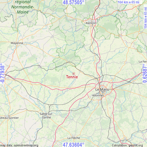
Tennie GPS coordinates[2]
48° 6' 27.684" North, 0° 4' 34.536" West
| Map corner | latitude | longitude |
|---|---|---|
| Upper-left | 48.57505°, | -0.77938° |
| Center: | 48.10769°, | -0.07626° |
| Lower-right: | 47.63604°, | 0.62687° |
| Map W x H: | 104.4×104.4 km | = 64.9×64.9mi |
| max Lat: | 51.07786° ⇑38.7% North |
| Tennie: | 48.10769° |
| min Lat: | ⇓61.3% South 41.3874° |
| min Long | Tennie | max Long |
| -5.08615° | -0.07626° | 9.52242° |
| W 21.3%⇐ | ⇒78.7% E |
Elevation
Elevation of Tennie is 96 m = 315 ft, and this is 97.7 m = 321 ft below average elevation for this country.
| Max E: |
2333 m = 7654 ft | 62.4% |
| Avg. | 193.7 m = 635 ft | |
| Tennie | 96 m = 315 ft | |
Min E: |
-1 m = -3 ft | 37.6% |
See also: France elevation on elevation.city.
Geographical zone
Tennie is located in North temperate zone (between Tropic of Cancer and the Arctic Circle). Distance of this North polar circle is 2052.1 km =1275.1 mi to North.| Distance of | km | miles | from Tennie |
|---|---|---|---|
| North Pole | 4658 | 2894.3 | to North |
| Arctic Circle | 2052.1 | 1275.1 | to North |
| Tropic Cancer | 2743.2 | 1704.5 | to South |
| Equator | 5349.1 | 3323.8 | to South |


Nearby cities:
15 places around Tennie: (largest is in red/bold)
• Bernay-en-Champagne
4.6 km =2.9 mi,  171°
171°
• Conlie
4.7 km =2.9 mi,  68°
68°
• Coulans-sur-Gée
11.6 km =7.2 mi,  146°
146°
• Crissé
6.9 km =4.3 mi,  10°
10°
• Degré
12.6 km =7.8 mi,  121°
121°
• Domfront-en-Champagne
7.8 km =4.8 mi,  92°
92°
• La Quinte
10.1 km =6.3 mi, 122°
• Lavardin
10.9 km =6.8 mi,  108°
108°
• Parennes
8.2 km =5.1 mi,  279°
279°
• Rouessé-Vassé
11.3 km =7 mi,  305°
305°
• Rouez
4.5 km =2.8 mi,  321°
321°
• Saint-Rémy-de-Sillé
8.8 km =5.5 mi,  351°
351°
• Saint-Symphorien
4.9 km =3 mi,  214°
214°
• Sillé-le-Guillaume
9.1 km =5.7 mi,  335°
335°
• Ségrie
12.7 km =7.9 mi,  36°
36°
Sources, notices
• [Note1] Compared only with cities in France existing in our database
• [Src1] Map data: © OpenStreetMap contributors (CC-BY-SA)
• [Src2] Other city data from geonames.org with taken over terms of usage.
• [Src3] Geographical zone / Annual Mean Temperature by Robert A. Rohde @ Wikipedia
