Sillé-le-Guillaume geodata
Sillé-le-Guillaume (Pays de la Loire) is a populated place; located in France in Europe/Paris (GMT+2) time zone. With population of 2,747 people, there are 3564 cities with bigger population in this country. Compared to other cities in France, 62.5% of cities are located further ↓South; 79% of cities are located further →East and 58% of cities have lower elevation than Sillé-le-Guillaume. Note1
Administrative division(s):
- Level 1: Pays de la Loire
- Level 2: Sarthe
- Level 3: Arrondissement de Mamers
- Level 4: Sillé-le-Guillaume


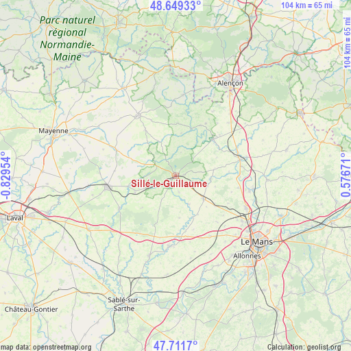
Sillé-le-Guillaume GPS coordinates[2]
48° 10' 57.576" North, 0° 7' 35.112" West
| Map corner | latitude | longitude |
|---|---|---|
| Upper-left | 48.64933°, | -0.82954° |
| Center: | 48.18266°, | -0.12642° |
| Lower-right: | 47.7117°, | 0.57671° |
| Map W x H: | 104.3×104.3 km | = 64.8×64.8mi |
| max Lat: | 51.07786° ⇑37.5% North |
| Sillé-le-Guillaume: | 48.18266° |
| min Lat: | ⇓62.5% South 41.3874° |
| min Long | Sillé-le-Guill | max Long |
| -5.08615° | -0.12642° | 9.52242° |
| W 21%⇐ | ⇒79% E |
Elevation
Elevation of Sillé-le-Guillaume is 161 m = 528 ft, and this is 32.7 m = 107 ft below average elevation for this country.
| Max E: |
2333 m = 7654 ft | 42% |
| Avg. | 193.7 m = 635 ft | |
| Sillé-le-Guillaume | 161 m = 528 ft | |
Min E: |
-1 m = -3 ft | 58% |
See also: France elevation on elevation.city.
Geographical zone
Sillé-le-Guillaume is located in North temperate zone (between Tropic of Cancer and the Arctic Circle). Distance of this North polar circle is 2043.8 km =1270 mi to North.| Distance of | km | miles | from Sillé-le-Guillaume |
|---|---|---|---|
| North Pole | 4649.7 | 2889.2 | to North |
| Arctic Circle | 2043.8 | 1270 | to North |
| Tropic Cancer | 2751.5 | 1709.7 | to South |
| Equator | 5357.4 | 3328.9 | to South |


Nearby cities:
15 places around Sillé-le-Guillaume: (largest is in red/bold)
• Bernay-en-Champagne
13.6 km =8.5 mi,  161°
161°
• Conlie
10.4 km =6.5 mi,  129°
129°
• Crissé
5.2 km =3.2 mi,  107°
107°
• Mont-Saint-Jean
7 km =4.3 mi,  10°
10°
• Parennes
8.2 km =5.1 mi,  211°
211°
• Rouessé-Vassé
5.7 km =3.5 mi,  251°
251°
• Rouez
4.9 km =3 mi,  169°
169°
• Saint-Georges-le-Gaultier
12.7 km =7.9 mi, 6°
• Saint-Pierre-sur-Orthe
6.7 km =4.2 mi,  297°
297°
• Saint-Rémy-de-Sillé
2.5 km =1.6 mi,  80°
80°
• Saint-Symphorien
12.4 km =7.7 mi,  175°
175°
• Ségrie
11.3 km =7 mi, 80°
• Tennie
9.1 km =5.7 mi, 155°
• Torcé-Viviers-en-Charnie
13.9 km =8.6 mi,  228°
228°
• Voutré
13.3 km =8.3 mi, 247°
Sources, notices
• [Note1] Compared only with cities in France existing in our database
• [Src1] Map data: © OpenStreetMap contributors (CC-BY-SA)
• [Src2] Other city data from geonames.org with taken over terms of usage.
• [Src3] Geographical zone / Annual Mean Temperature by Robert A. Rohde @ Wikipedia
