Parennes geodata
Parennes (Pays de la Loire) is a populated place; located in France in Europe/Paris (GMT+2) time zone. With population of 518 people, there are 14866 cities with bigger population in this country. Compared to other cities in France, 61.5% of cities are located further ↓South; 79.5% of cities are located further →East and 54.2% of cities have lower elevation than Parennes. Note1
Administrative division(s):
- Level 1: Pays de la Loire
- Level 2: Sarthe
- Level 3: Arrondissement de Mamers
- Level 4: Parennes


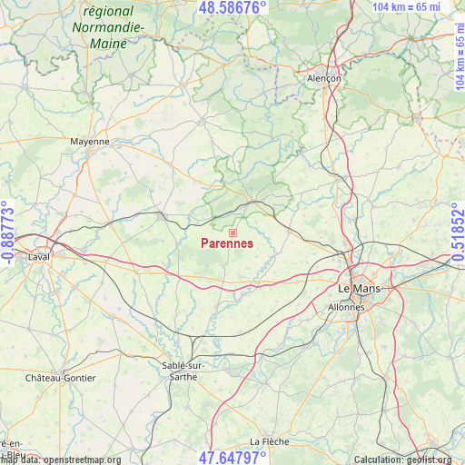
Parennes GPS coordinates[2]
48° 7' 10.236" North, 0° 11' 4.596" West
| Map corner | latitude | longitude |
|---|---|---|
| Upper-left | 48.58676°, | -0.88773° |
| Center: | 48.11951°, | -0.18461° |
| Lower-right: | 47.64797°, | 0.51852° |
| Map W x H: | 104.4×104.4 km | = 64.9×64.9mi |
| max Lat: | 51.07786° ⇑38.5% North |
| Parennes: | 48.11951° |
| min Lat: | ⇓61.5% South 41.3874° |
| min Long | Parennes | max Long |
| -5.08615° | -0.18461° | 9.52242° |
| W 20.5%⇐ | ⇒79.5% E |
Elevation
Elevation of Parennes is 147 m = 482 ft, and this is 46.7 m = 153 ft below average elevation for this country.
| Max E: |
2333 m = 7654 ft | 45.8% |
| Avg. | 193.7 m = 635 ft | |
| Parennes | 147 m = 482 ft | |
Min E: |
-1 m = -3 ft | 54.2% |
See also: France elevation on elevation.city.
Geographical zone
Parennes is located in North temperate zone (between Tropic of Cancer and the Arctic Circle). Distance of this North polar circle is 2050.8 km =1274.3 mi to North.| Distance of | km | miles | from Parennes |
|---|---|---|---|
| North Pole | 4656.7 | 2893.5 | to North |
| Arctic Circle | 2050.8 | 1274.3 | to North |
| Tropic Cancer | 2744.5 | 1705.4 | to South |
| Equator | 5350.4 | 3324.6 | to South |


Nearby cities:
15 places around Parennes: (largest is in red/bold)
• Bernay-en-Champagne
10.5 km =6.5 mi,  123°
123°
• Conlie
12.4 km =7.7 mi,  88°
88°
• Crissé
10.7 km =6.6 mi,  59°
59°
• Joué-en-Charnie
11.3 km =7 mi,  182°
182°
• Loué
13.9 km =8.6 mi,  170°
170°
• Rouessé-Vassé
5.4 km =3.4 mi,  347°
347°
• Rouez
5.7 km =3.5 mi,  66°
66°
• Saint-Pierre-sur-Orthe
10.3 km =6.4 mi, 350°
• Saint-Rémy-de-Sillé
10 km =6.2 mi,  42°
42°
• Saint-Symphorien
7.5 km =4.7 mi,  135°
135°
• Sainte-Suzanne
12.8 km =8 mi,  259°
259°
• Sillé-le-Guillaume
8.2 km =5.1 mi,  31°
31°
• Tennie
8.2 km =5.1 mi,  99°
99°
• Torcé-Viviers-en-Charnie
6.5 km =4 mi,  250°
250°
• Voutré
8.2 km =5.1 mi,  283°
283°
Sources, notices
• [Note1] Compared only with cities in France existing in our database
• [Src1] Map data: © OpenStreetMap contributors (CC-BY-SA)
• [Src2] Other city data from geonames.org with taken over terms of usage.
• [Src3] Geographical zone / Annual Mean Temperature by Robert A. Rohde @ Wikipedia
