Tavaux geodata
Tavaux (Bourgogne-Franche-Comté) is a populated place; located in France in Europe/Paris (GMT+2) time zone. With population of 4,066 people, there are 2417 cities with bigger population in this country. Compared to other cities in France, 54.9% of cities are located further ↑North; 81.9% of cities are located further ←West and 64.6% of cities have lower elevation than Tavaux. Note1
Administrative division(s):
- Level 1: Bourgogne-Franche-Comté
- Level 2: Jura
- Level 3: Arrondissement de Dole
- Level 4: Tavaux


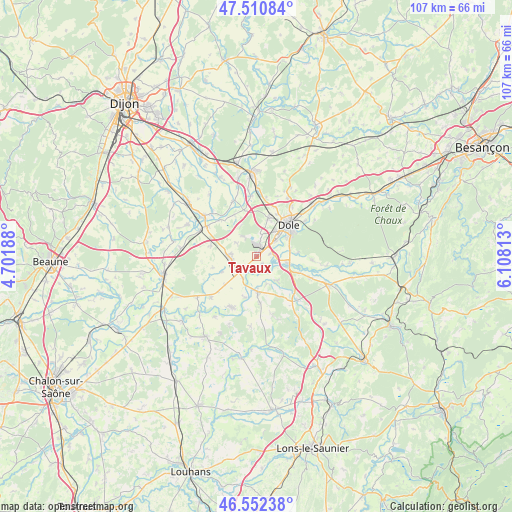
Tavaux GPS coordinates[2]
47° 2' 1.536" North, 5° 24' 18" East
| Map corner | latitude | longitude |
|---|---|---|
| Upper-left | 47.51084°, | 4.70188° |
| Center: | 47.03376°, | 5.405° |
| Lower-right: | 46.55238°, | 6.10813° |
| Map W x H: | 106.6×106.6 km | = 66.2×66.2mi |
| max Lat: | 51.07786° ⇑54.9% North |
| Tavaux: | 47.03376° |
| min Lat: | ⇓45.1% South 41.3874° |
| min Long | Tavaux | max Long |
| -5.08615° | 5.405° | 9.52242° |
| W 81.9%⇐ | ⇒18.1% E |
Elevation
Elevation of Tavaux is 192 m = 630 ft, and this is 1.7 m = 6 ft below average elevation for this country.
| Max E: |
2333 m = 7654 ft | 35.4% |
| Avg. | 193.7 m = 635 ft | |
| Tavaux | 192 m = 630 ft | |
Min E: |
-1 m = -3 ft | 64.6% |
See also: France elevation on elevation.city.
Geographical zone
Tavaux is located in North temperate zone (between Tropic of Cancer and the Arctic Circle). Distance of this North polar circle is 2171.5 km =1349.3 mi to North.| Distance of | km | miles | from Tavaux |
|---|---|---|---|
| North Pole | 4777.4 | 2968.5 | to North |
| Arctic Circle | 2171.5 | 1349.3 | to North |
| Tropic Cancer | 2623.7 | 1630.3 | to South |
| Equator | 5229.7 | 3249.6 | to South |


Nearby cities:
15 places around Tavaux: (largest is in red/bold)
• Abergement-la-Ronce
4.7 km =2.9 mi,  326°
326°
• Asnans-Beauvoisin
9.4 km =5.8 mi,  174°
174°
• Champvans
8.3 km =5.2 mi,  17°
17°
• Chaussin
7.5 km =4.7 mi,  178°
178°
• Choisey
5.3 km =3.3 mi,  50°
50°
• Crissey
7 km =4.3 mi,  57°
57°
• Damparis
4.7 km =2.9 mi,  8°
8°
• Dole
9.1 km =5.7 mi,  44°
44°
• Foucherans
6.5 km =4 mi, 35°
• Gevry
3 km =1.9 mi,  77°
77°
• Longwy-sur-le-Doubs
8.8 km =5.5 mi,  195°
195°
• Parcey
6.3 km =3.9 mi,  102°
102°
• Saint-Aubin
5.9 km =3.7 mi,  269°
269°
• Sampans
11 km =6.8 mi, 20°
• Villette-lès-Dole
7.1 km =4.4 mi, 79°
Sources, notices
• [Note1] Compared only with cities in France existing in our database
• [Src1] Map data: © OpenStreetMap contributors (CC-BY-SA)
• [Src2] Other city data from geonames.org with taken over terms of usage.
• [Src3] Geographical zone / Annual Mean Temperature by Robert A. Rohde @ Wikipedia
