Champvans geodata
Champvans (Bourgogne-Franche-Comté) is a populated place; located in France in Europe/Paris (GMT+2) time zone. With population of 1,418 people, there are 6526 cities with bigger population in this country. Compared to other cities in France, 54.2% of cities are located further ↑North; 82.4% of cities are located further ←West and 70.4% of cities have lower elevation than Champvans. Note1
Administrative division(s):
- Level 1: Bourgogne-Franche-Comté
- Level 2: Jura
- Level 3: Arrondissement de Dole
- Level 4: Champvans


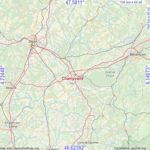
Champvans GPS coordinates[2]
47° 6' 16.776" North, 5° 26' 15.36" East
| Map corner | latitude | longitude |
|---|---|---|
| Upper-left | 47.5811°, | 4.73448° |
| Center: | 47.10466°, | 5.4376° |
| Lower-right: | 46.62392°, | 6.14073° |
| Map W x H: | 106.4×106.4 km | = 66.1×66.1mi |
| max Lat: | 51.07786° ⇑54.2% North |
| Champvans: | 47.10466° |
| min Lat: | ⇓45.8% South 41.3874° |
| min Long | Champvans | max Long |
| -5.08615° | 5.4376° | 9.52242° |
| W 82.4%⇐ | ⇒17.6% E |
Elevation
Elevation of Champvans is 221 m = 725 ft, and this is 27.3 m = 90 ft above average elevation for this country.
| Max E: |
2333 m = 7654 ft | 29.6% |
| Champvans | 221 m 725 ft | |
| Avg. | 193.7 m = 635 ft | |
Min E: |
-1 m = -3 ft | 70.4% |
See also: France elevation on elevation.city.
Geographical zone
Champvans is located in North temperate zone (between Tropic of Cancer and the Arctic Circle). Distance of this North polar circle is 2163.6 km =1344.4 mi to North.| Distance of | km | miles | from Champvans |
|---|---|---|---|
| North Pole | 4769.5 | 2963.6 | to North |
| Arctic Circle | 2163.6 | 1344.4 | to North |
| Tropic Cancer | 2631.6 | 1635.2 | to South |
| Equator | 5237.5 | 3254.4 | to South |


Nearby cities:
15 places around Champvans: (largest is in red/bold)
• Abergement-la-Ronce
6.4 km =4 mi,  231°
231°
• Authume
5.5 km =3.4 mi,  62°
62°
• Brevans
6.7 km =4.2 mi,  97°
97°
• Choisey
4.8 km =3 mi,  160°
160°
• Crissey
5.4 km =3.4 mi,  139°
139°
• Damparis
3.7 km =2.3 mi,  208°
208°
• Dole
4.2 km =2.6 mi,  109°
109°
• Foucherans
2.9 km =1.8 mi,  153°
153°
• Gevry
7.2 km =4.5 mi,  176°
176°
• Les Maillys
8.2 km =5.1 mi,  294°
294°
• Parcey
10 km =6.2 mi, 158°
• Rochefort-sur-Nenon
9.7 km =6 mi,  76°
76°
• Sampans
2.8 km =1.7 mi,  31°
31°
• Tavaux
8.3 km =5.2 mi,  197°
197°
• Villette-lès-Dole
7.9 km =4.9 mi, 145°
Sources, notices
• [Note1] Compared only with cities in France existing in our database
• [Src1] Map data: © OpenStreetMap contributors (CC-BY-SA)
• [Src2] Other city data from geonames.org with taken over terms of usage.
• [Src3] Geographical zone / Annual Mean Temperature by Robert A. Rohde @ Wikipedia
