Longwy-sur-le-Doubs geodata
Longwy-sur-le-Doubs (Bourgogne-Franche-Comté) is a populated place; located in France in Europe/Paris (GMT+2) time zone. With population of 510 people, there are 15036 cities with bigger population in this country. Compared to other cities in France, 55.7% of cities are located further ↑North; 81.4% of cities are located further ←West and 63.3% of cities have lower elevation than Longwy-sur-le-Doubs. Note1
Administrative division(s):
- Level 1: Bourgogne-Franche-Comté
- Level 2: Jura
- Level 3: Arrondissement de Dole
- Level 4: Longwy-sur-le-Doubs


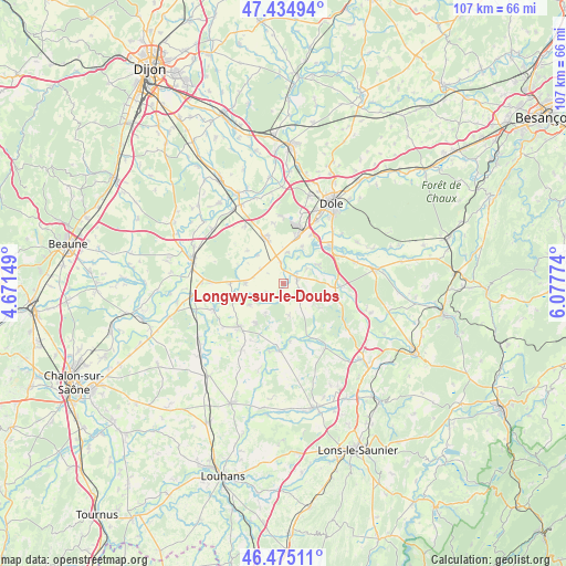
Longwy-sur-le-Doubs GPS coordinates[2]
46° 57' 25.848" North, 5° 22' 28.632" East
| Map corner | latitude | longitude |
|---|---|---|
| Upper-left | 47.43494°, | 4.67149° |
| Center: | 46.95718°, | 5.37462° |
| Lower-right: | 46.47511°, | 6.07774° |
| Map W x H: | 106.7×106.7 km | = 66.3×66.3mi |
| max Lat: | 51.07786° ⇑55.7% North |
| Longwy-sur-le-Doubs: | 46.95718° |
| min Lat: | ⇓44.3% South 41.3874° |
| min Long | Longwy-sur-le-D | max Long |
| -5.08615° | 5.37462° | 9.52242° |
| W 81.4%⇐ | ⇒18.6% E |
Elevation
Elevation of Longwy-sur-le-Doubs is 186 m = 610 ft, and this is 7.7 m = 25 ft below average elevation for this country.
| Max E: |
2333 m = 7654 ft | 36.7% |
| Avg. | 193.7 m = 635 ft | |
| Longwy-sur-le-Doubs | 186 m = 610 ft | |
Min E: |
-1 m = -3 ft | 63.3% |
See also: France elevation on elevation.city.
Geographical zone
Longwy-sur-le-Doubs is located in North temperate zone (between Tropic of Cancer and the Arctic Circle). Distance of this North polar circle is 2180 km =1354.6 mi to North.| Distance of | km | miles | from Longwy-sur-le-Doubs |
|---|---|---|---|
| North Pole | 4785.9 | 2973.8 | to North |
| Arctic Circle | 2180 | 1354.6 | to North |
| Tropic Cancer | 2615.2 | 1625 | to South |
| Equator | 5221.1 | 3244.2 | to South |


Nearby cities:
15 places around Longwy-sur-le-Doubs: (largest is in red/bold)
• Abergement-la-Ronce
12.4 km =7.7 mi,  358°
358°
• Asnans-Beauvoisin
3.3 km =2.1 mi,  104°
104°
• Chaussin
2.7 km =1.7 mi,  68°
68°
• Choisey
13.5 km =8.4 mi,  28°
28°
• Crissey
14.8 km =9.2 mi, 33°
• Damparis
13.5 km =8.4 mi,  12°
12°
• Gevry
10.6 km =6.6 mi, 29°
• La Chapelle-Saint-Sauveur
14.7 km =9.1 mi,  212°
212°
• Le Deschaux
9.7 km =6 mi,  93°
93°
• Parcey
11.1 km =6.9 mi,  49°
49°
• Petit-Noir
4.1 km =2.5 mi,  229°
229°
• Pierre-de-Bresse
12.5 km =7.8 mi, 229°
• Saint-Aubin
9.2 km =5.7 mi,  336°
336°
• Tavaux
8.8 km =5.5 mi,  15°
15°
• Villette-lès-Dole
13.5 km =8.4 mi,  43°
43°
Sources, notices
• [Note1] Compared only with cities in France existing in our database
• [Src1] Map data: © OpenStreetMap contributors (CC-BY-SA)
• [Src2] Other city data from geonames.org with taken over terms of usage.
• [Src3] Geographical zone / Annual Mean Temperature by Robert A. Rohde @ Wikipedia
