Borgo geodata
Borgo (Corsica) is a populated place; located in France in Europe/Paris (GMT+2) time zone. With population of 5,538 people, there are 1790 cities with bigger population in this country. Compared to other cities in France, 99.4% of cities are located further ↑North; 99.8% of cities are located further ←West and 77.3% of cities have lower elevation than Borgo. Note1
Administrative division(s):
- Level 1: Corsica
- Level 2: Département de la Haute-Corse
- Level 3: Arrondissement de Bastia
- Level 4: Borgo


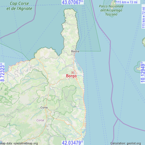
Borgo GPS coordinates[2]
42° 33' 17.568" North, 9° 25' 34.896" East
| Map corner | latitude | longitude |
|---|---|---|
| Upper-left | 43.07067°, | 8.72323° |
| Center: | 42.55488°, | 9.42636° |
| Lower-right: | 42.03479°, | 10.12949° |
| Map W x H: | 115.2×115.2 km | = 71.6×71.6mi |
| max Lat: | 51.07786° ⇑99.4% North |
| Borgo: | 42.55488° |
| min Lat: | ⇓0.6% South 41.3874° |
| min Long | Borgo | max Long |
| -5.08615° | 9.42636° | 9.52242° |
| W 99.8%⇐ | ⇒0.2% E |
Elevation
Elevation of Borgo is 266 m = 873 ft, and this is 72.3 m = 237 ft above average elevation for this country.
| Max E: |
2333 m = 7654 ft | 22.7% |
| Borgo | 266 m 873 ft | |
| Avg. | 193.7 m = 635 ft | |
Min E: |
-1 m = -3 ft | 77.3% |
See also: France elevation on elevation.city.
Geographical zone
Borgo is located in North temperate zone (between Tropic of Cancer and the Arctic Circle). Distance of this Northern Tropic circle is 2125.7 km =1320.8 mi to South.| Distance of | km | miles | from Borgo |
|---|---|---|---|
| North Pole | 5275.4 | 3278 | to North |
| Arctic Circle | 2669.5 | 1658.7 | to North |
| Tropic Cancer | 2125.7 | 1320.8 | to South |
| Equator | 4731.7 | 2940.1 | to South |


Nearby cities:
15 places around Borgo: (largest is in red/bold)
• Bastia
16.6 km =10.3 mi,  6°
6°
• Biguglia
8 km =5 mi,  356°
356°
• Castellare-di-Casinca
10.5 km =6.5 mi,  157°
157°
• Furiani
11.6 km =7.2 mi, 355°
• Lucciana
1.2 km =0.7 mi,  212°
212°
• Morosaglia
16.9 km =10.5 mi,  217°
217°
• Murato
8.5 km =5.3 mi,  287°
287°
• Oletta
10.2 km =6.3 mi,  324°
324°
• Patrimonio
16.7 km =10.4 mi,  341°
341°
• Penta-di-Casinca
10.3 km =6.4 mi, 164°
• Sorbo-Ocagnano
9.1 km =5.7 mi, 164°
• Taglio
13.8 km =8.6 mi,  165°
165°
• Talasani
16.9 km =10.5 mi, 164°
• Vescovato
7 km =4.3 mi, 171°
• Vignale
12.5 km =7.8 mi, 221°
Sources, notices
• [Note1] Compared only with cities in France existing in our database
• [Src1] Map data: © OpenStreetMap contributors (CC-BY-SA)
• [Src2] Other city data from geonames.org with taken over terms of usage.
• [Src3] Geographical zone / Annual Mean Temperature by Robert A. Rohde @ Wikipedia
