Taizé geodata
Taizé (Nouvelle-Aquitaine) is a populated place; located in France in Europe/Paris (GMT+2) time zone. With population of 758 people, there are 11078 cities with bigger population in this country. Compared to other cities in France, 56% of cities are located further ↑North; 79% of cities are located further →East and 66% of cities have higher elevation than Taizé. Note1
Administrative division(s):
- Level 1: Nouvelle-Aquitaine
- Level 2: Département des Deux-Sèvres
- Level 3: Arrondissement de Bressuire
- Level 4: Plaine-et-Vallées


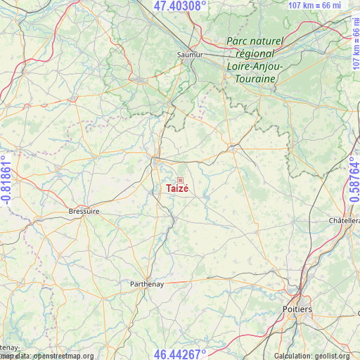
Taizé GPS coordinates[2]
46° 55' 30.108" North, 0° 6' 55.764" West
| Map corner | latitude | longitude |
|---|---|---|
| Upper-left | 47.40308°, | -0.81861° |
| Center: | 46.92503°, | -0.11549° |
| Lower-right: | 46.44267°, | 0.58764° |
| Map W x H: | 106.8×106.8 km | = 66.4×66.4mi |
| max Lat: | 51.07786° ⇑56% North |
| Taizé: | 46.92503° |
| min Lat: | ⇓44% South 41.3874° |
| min Long | Taizé | max Long |
| -5.08615° | -0.11549° | 9.52242° |
| W 21%⇐ | ⇒79% E |
Elevation
Elevation of Taizé is 87 m = 285 ft, and this is 106.7 m = 350 ft below average elevation for this country.
| Max E: |
2333 m = 7654 ft | 66% |
| Avg. | 193.7 m = 635 ft | |
| Taizé | 87 m = 285 ft | |
Min E: |
-1 m = -3 ft | 34% |
See also: France elevation on elevation.city.
Geographical zone
Taizé is located in North temperate zone (between Tropic of Cancer and the Arctic Circle). Distance of this North polar circle is 2183.6 km =1356.8 mi to North.| Distance of | km | miles | from Taizé |
|---|---|---|---|
| North Pole | 4789.5 | 2976.1 | to North |
| Arctic Circle | 2183.6 | 1356.8 | to North |
| Tropic Cancer | 2611.7 | 1622.8 | to South |
| Equator | 5217.6 | 3242.1 | to South |


Nearby cities:
15 places around Taizé: (largest is in red/bold)
• Airvault
11 km =6.8 mi,  188°
188°
• Glénay
12.6 km =7.8 mi,  235°
235°
• Louzy
11.1 km =6.9 mi,  330°
330°
• Luzay
6.1 km =3.8 mi,  268°
268°
• Missé
6.4 km =4 mi,  293°
293°
• Moncontour
8.9 km =5.5 mi,  122°
122°
• Mouterre-Silly
13.4 km =8.3 mi,  65°
65°
• Oiron
3.9 km =2.4 mi,  41°
41°
• Saint-Jean-de-Thouars
8.5 km =5.3 mi,  300°
300°
• Saint-Jouin-de-Marnes
6.7 km =4.2 mi,  137°
137°
• Saint-Léger-de-Montbrun
8.4 km =5.2 mi,  350°
350°
• Saint-Varent
9.7 km =6 mi,  246°
246°
• Sainte-Radegonde
12.1 km =7.5 mi, 302°
• Sainte-Verge
11.7 km =7.3 mi,  321°
321°
• Thouars
9.6 km =6 mi,  310°
310°
Sources, notices
• [Note1] Compared only with cities in France existing in our database
• [Src1] Map data: © OpenStreetMap contributors (CC-BY-SA)
• [Src2] Other city data from geonames.org with taken over terms of usage.
• [Src3] Geographical zone / Annual Mean Temperature by Robert A. Rohde @ Wikipedia
