Montaure geodata
Montaure (Normandy) is a populated place; located in France in Europe/Paris (GMT+2) time zone. With population of 1,127 people, there are 7965 cities with bigger population in this country. Compared to other cities in France, 84.9% of cities are located further ↓South; 67.9% of cities are located further →East and 50.8% of cities have lower elevation than Montaure. Note1
Administrative division(s):
- Level 1: Normandy
- Level 2: Département de l'Eure
- Level 3: Les Andelys
- Level 4: Terres de Bord


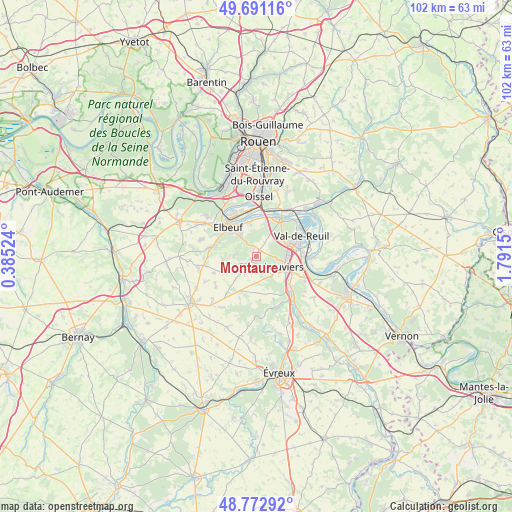
Montaure GPS coordinates[2]
49° 14' 3.012" North, 1° 5' 18.132" East
| Map corner | latitude | longitude |
|---|---|---|
| Upper-left | 49.69116°, | 0.38524° |
| Center: | 49.23417°, | 1.08837° |
| Lower-right: | 48.77292°, | 1.7915° |
| Map W x H: | 102.1×102.1 km | = 63.4×63.4mi |
| max Lat: | 51.07786° ⇑15.1% North |
| Montaure: | 49.23417° |
| min Lat: | ⇓84.9% South 41.3874° |
| min Long | Montaure | max Long |
| -5.08615° | 1.08837° | 9.52242° |
| W 32.1%⇐ | ⇒67.9% E |
Elevation
Elevation of Montaure is 135 m = 443 ft, and this is 58.7 m = 193 ft below average elevation for this country.
| Max E: |
2333 m = 7654 ft | 49.2% |
| Avg. | 193.7 m = 635 ft | |
| Montaure | 135 m = 443 ft | |
Min E: |
-1 m = -3 ft | 50.8% |
See also: France elevation on elevation.city.
Geographical zone
Montaure is located in North temperate zone (between Tropic of Cancer and the Arctic Circle). Distance of this North polar circle is 1926.8 km =1197.3 mi to North.| Distance of | km | miles | from Montaure |
|---|---|---|---|
| North Pole | 4532.7 | 2816.5 | to North |
| Arctic Circle | 1926.8 | 1197.3 | to North |
| Tropic Cancer | 2868.4 | 1782.3 | to South |
| Equator | 5474.3 | 3401.6 | to South |


Nearby cities:
15 places around Montaure: (largest is in red/bold)
• Acquigny
9.3 km =5.8 mi,  136°
136°
• Canappeville
8.7 km =5.4 mi,  174°
174°
• Caudebec-lès-Elbeuf
7.1 km =4.4 mi,  317°
317°
• Criquebeuf-sur-Seine
8 km =5 mi,  5°
5°
• Elbeuf
8.5 km =5.3 mi,  313°
313°
• Freneuse
9.2 km =5.7 mi,  357°
357°
• La Haye-Malherbe
1.8 km =1.1 mi,  237°
237°
• La Saussaye
8.3 km =5.2 mi,  289°
289°
• Le Vaudreuil
9.1 km =5.7 mi,  75°
75°
• Louviers
6 km =3.7 mi,  108°
108°
• Pinterville
7.9 km =4.9 mi,  126°
126°
• Saint-Didier-des-Bois
4.1 km =2.5 mi,  275°
275°
• Saint-Pierre-des-Fleurs
9 km =5.6 mi, 281°
• Saint-Pierre-lès-Elbeuf
6 km =3.7 mi,  326°
326°
• Surville
4.2 km =2.6 mi,  164°
164°
Sources, notices
• [Note1] Compared only with cities in France existing in our database
• [Src1] Map data: © OpenStreetMap contributors (CC-BY-SA)
• [Src2] Other city data from geonames.org with taken over terms of usage.
• [Src3] Geographical zone / Annual Mean Temperature by Robert A. Rohde @ Wikipedia
