Saint-Étienne-du-Vauvray geodata
Saint-Étienne-du-Vauvray (Normandy) is a populated place; located in France in Europe/Paris (GMT+2) time zone. With population of 724 people, there are 11480 cities with bigger population in this country. Compared to other cities in France, 85% of cities are located further ↓South; 66.5% of cities are located further →East and 91.6% of cities have higher elevation than Saint-Étienne-du-Vauvray. Note1
Administrative division(s):
- Level 1: Normandy
- Level 2: Département de l'Eure
- Level 3: Les Andelys
- Level 4: Saint-Étienne-du-Vauvray
Current local time in Saint-Étienne-du-Vauvray:
10:00 AM, SaturdayDifference from your time zone: hours


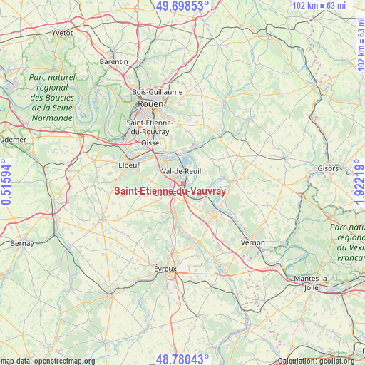
Saint-Étienne-du-Vauvray GPS coordinates[2]
49° 14' 29.796" North, 1° 13' 8.616" East
| Map corner | latitude | longitude |
|---|---|---|
| Upper-left | 49.69853°, | 0.51594° |
| Center: | 49.24161°, | 1.21906° |
| Lower-right: | 48.78043°, | 1.92219° |
| Map W x H: | 102.1×102.1 km | = 63.4×63.4mi |
| max Lat: | 51.07786° ⇑15% North |
| Saint-Étienne-du-Vauvray: | 49.24161° |
| min Lat: | ⇓85% South 41.3874° |
| min Long | Saint-Étienne- | max Long |
| -5.08615° | 1.21906° | 9.52242° |
| W 33.5%⇐ | ⇒66.5% E |
Elevation
Elevation of Saint-Étienne-du-Vauvray is 26 m = 85 ft, and this is 167.7 m = 550 ft below average elevation for this country.
| Max E: |
2333 m = 7654 ft | 91.6% |
| Avg. | 193.7 m = 635 ft | |
| Saint-Étienne-du-Vauvray | 26 m = 85 ft | |
Min E: |
-1 m = -3 ft | 8.4% |
See also: France elevation on elevation.city.
Geographical zone
Saint-Étienne-du-Vauvray is located in North temperate zone (between Tropic of Cancer and the Arctic Circle). Distance of this North polar circle is 1926 km =1196.8 mi to North.| Distance of | km | miles | from Saint-Étienne-du-Vauvray |
|---|---|---|---|
| North Pole | 4531.9 | 2816 | to North |
| Arctic Circle | 1926 | 1196.8 | to North |
| Tropic Cancer | 2869.2 | 1782.8 | to South |
| Equator | 5475.2 | 3402.1 | to South |


Nearby cities:
15 places around Saint-Étienne-du-Vauvray: (largest is in red/bold)
• Acquigny
8.2 km =5.1 mi,  202°
202°
• Andé
1.9 km =1.2 mi,  125°
125°
• Fontaine-Bellenger
6.9 km =4.3 mi,  153°
153°
• Heudebouville
5.4 km =3.4 mi,  163°
163°
• Le Manoir
8.1 km =5 mi,  352°
352°
• Le Vaudreuil
1.5 km =0.9 mi,  333°
333°
• Les Damps
7.4 km =4.6 mi,  335°
335°
• Louviers
4.7 km =2.9 mi,  233°
233°
• Léry
5 km =3.1 mi, 350°
• Muids
5.6 km =3.5 mi,  111°
111°
• Pinterville
6.4 km =4 mi,  209°
209°
• Poses
7.3 km =4.5 mi,  14°
14°
• Saint-Pierre-du-Vauvray
1.1 km =0.7 mi,  171°
171°
• Val-de-Reuil
3.6 km =2.2 mi, 349°
• Venables
7.3 km =4.5 mi, 130°
Sources, notices
• [Note1] Compared only with cities in France existing in our database
• [Src1] Map data: © OpenStreetMap contributors (CC-BY-SA)
• [Src2] Other city data from geonames.org with taken over terms of usage.
• [Src3] Geographical zone / Annual Mean Temperature by Robert A. Rohde @ Wikipedia
