Surgères geodata
Surgères (Nouvelle-Aquitaine) is a populated place; located in France in Europe/Paris (GMT+2) time zone. With population of 5,888 people, there are 1679 cities with bigger population in this country. Compared to other cities in France, 64.9% of cities are located further ↑North; 86% of cities are located further →East and 89.5% of cities have higher elevation than Surgères. Note1
Administrative division(s):
- Level 1: Nouvelle-Aquitaine
- Level 2: Charente-Maritime
- Level 3: Arrondissement de Rochefort
- Level 4: Surgères


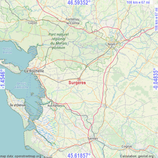
Surgères GPS coordinates[2]
46° 6' 29.52" North, 0° 45' 5.328" West
| Map corner | latitude | longitude |
|---|---|---|
| Upper-left | 46.59352°, | -1.4546° |
| Center: | 46.1082°, | -0.75148° |
| Lower-right: | 45.61857°, | -0.04835° |
| Map W x H: | 108.4×108.4 km | = 67.4×67.4mi |
| max Lat: | 51.07786° ⇑64.9% North |
| Surgères: | 46.1082° |
| min Lat: | ⇓35.1% South 41.3874° |
| min Long | Surgères | max Long |
| -5.08615° | -0.75148° | 9.52242° |
| W 14%⇐ | ⇒86% E |
Elevation
Elevation of Surgères is 31 m = 102 ft, and this is 162.7 m = 534 ft below average elevation for this country.
| Max E: |
2333 m = 7654 ft | 89.5% |
| Avg. | 193.7 m = 635 ft | |
| Surgères | 31 m = 102 ft | |
Min E: |
-1 m = -3 ft | 10.5% |
See also: France elevation on elevation.city.
Geographical zone
Surgères is located in North temperate zone (between Tropic of Cancer and the Arctic Circle). Distance of this North polar circle is 2274.4 km =1413.2 mi to North.| Distance of | km | miles | from Surgères |
|---|---|---|---|
| North Pole | 4880.3 | 3032.5 | to North |
| Arctic Circle | 2274.4 | 1413.2 | to North |
| Tropic Cancer | 2520.8 | 1566.4 | to South |
| Equator | 5126.8 | 3185.6 | to South |


Nearby cities:
15 places around Surgères: (largest is in red/bold)
• Ardillières
12.2 km =7.6 mi,  243°
243°
• Benon
11.9 km =7.4 mi,  335°
335°
• Bernay-Saint-Martin
11.4 km =7.1 mi,  113°
113°
• Chambon
7.9 km =4.9 mi,  286°
286°
• Forges
11.1 km =6.9 mi,  268°
268°
• Genouillé
9.9 km =6.2 mi,  194°
194°
• Landrais
9.5 km =5.9 mi, 243°
• Marsais
11.8 km =7.3 mi,  80°
80°
• Mauzé-sur-le-Mignon
11.7 km =7.3 mi,  33°
33°
• Muron
10.1 km =6.3 mi,  215°
215°
• Saint-Georges-du-Bois
3.9 km =2.4 mi,  20°
20°
• Saint-Germain-de-Marencennes
4.6 km =2.9 mi, 221°
• Saint-Mard
4 km =2.5 mi,  128°
128°
• Saint-Saturnin-du-Bois
7.1 km =4.4 mi,  60°
60°
• Vandré
5.9 km =3.7 mi, 189°
Sources, notices
• [Note1] Compared only with cities in France existing in our database
• [Src1] Map data: © OpenStreetMap contributors (CC-BY-SA)
• [Src2] Other city data from geonames.org with taken over terms of usage.
• [Src3] Geographical zone / Annual Mean Temperature by Robert A. Rohde @ Wikipedia
