Vandré geodata
Vandré (Nouvelle-Aquitaine) is a populated place; located in France in Europe/Paris (GMT+2) time zone. With population of 773 people, there are 10903 cities with bigger population in this country. Compared to other cities in France, 65.7% of cities are located further ↑North; 86.1% of cities are located further →East and 94.4% of cities have higher elevation than Vandré. Note1
Administrative division(s):
- Level 1: Nouvelle-Aquitaine
- Level 2: Charente-Maritime
- Level 3: Arrondissement de Rochefort
- Level 4: La Devise


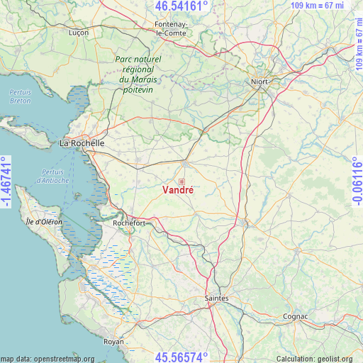
Vandré GPS coordinates[2]
46° 3' 20.988" North, 0° 45' 51.408" West
| Map corner | latitude | longitude |
|---|---|---|
| Upper-left | 46.54161°, | -1.46741° |
| Center: | 46.05583°, | -0.76428° |
| Lower-right: | 45.56574°, | -0.06116° |
| Map W x H: | 108.5×108.5 km | = 67.4×67.4mi |
| max Lat: | 51.07786° ⇑65.7% North |
| Vandré: | 46.05583° |
| min Lat: | ⇓34.3% South 41.3874° |
| min Long | Vandré | max Long |
| -5.08615° | -0.76428° | 9.52242° |
| W 13.9%⇐ | ⇒86.1% E |
Elevation
Elevation of Vandré is 19 m = 62 ft, and this is 174.7 m = 573 ft below average elevation for this country.
| Max E: |
2333 m = 7654 ft | 94.4% |
| Avg. | 193.7 m = 635 ft | |
| Vandré | 19 m = 62 ft | |
Min E: |
-1 m = -3 ft | 5.6% |
See also: France elevation on elevation.city.
Geographical zone
Vandré is located in North temperate zone (between Tropic of Cancer and the Arctic Circle). Distance of this North polar circle is 2280.2 km =1416.9 mi to North.| Distance of | km | miles | from Vandré |
|---|---|---|---|
| North Pole | 4886.1 | 3036.1 | to North |
| Arctic Circle | 2280.2 | 1416.9 | to North |
| Tropic Cancer | 2515 | 1562.7 | to South |
| Equator | 5120.9 | 3182 | to South |


Nearby cities:
15 places around Vandré: (largest is in red/bold)
• Ardillières
9.9 km =6.2 mi,  271°
271°
• Bernay-Saint-Martin
11.5 km =7.1 mi,  83°
83°
• Chambon
10.4 km =6.5 mi,  320°
320°
• Forges
11.5 km =7.1 mi,  298°
298°
• Genouillé
4 km =2.5 mi,  202°
202°
• Landrais
7.7 km =4.8 mi,  281°
281°
• Le Thou
12.1 km =7.5 mi, 284°
• Lussant
11.5 km =7.1 mi, 203°
• Muron
5.5 km =3.4 mi,  244°
244°
• Saint-Georges-du-Bois
9.7 km =6 mi,  13°
13°
• Saint-Germain-de-Marencennes
3.2 km =2 mi, 318°
• Saint-Mard
5.3 km =3.3 mi,  50°
50°
• Saint-Saturnin-du-Bois
11.8 km =7.3 mi,  37°
37°
• Surgères
5.9 km =3.7 mi, 9°
• Tonnay-Boutonne
10.7 km =6.6 mi,  156°
156°
Sources, notices
• [Note1] Compared only with cities in France existing in our database
• [Src1] Map data: © OpenStreetMap contributors (CC-BY-SA)
• [Src2] Other city data from geonames.org with taken over terms of usage.
• [Src3] Geographical zone / Annual Mean Temperature by Robert A. Rohde @ Wikipedia
