Steinbourg geodata
Steinbourg (Grand Est) is a populated place; located in France in Europe/Paris (GMT+2) time zone. With population of 1,939 people, there are 4938 cities with bigger population in this country. Compared to other cities in France, 74.9% of cities are located further ↓South; 97.4% of cities are located further ←West and 64.9% of cities have lower elevation than Steinbourg. Note1
Administrative division(s):
- Level 1: Grand Est
- Level 2: Bas-Rhin
- Level 3: Arrondissement de Saverne
- Level 4: Steinbourg


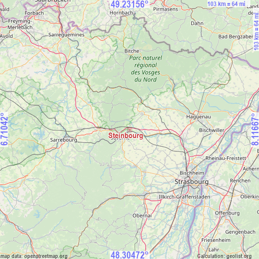
Steinbourg GPS coordinates[2]
48° 46' 13.008" North, 7° 24' 48.744" East
| Map corner | latitude | longitude |
|---|---|---|
| Upper-left | 49.23156°, | 6.71042° |
| Center: | 48.77028°, | 7.41354° |
| Lower-right: | 48.30472°, | 8.11667° |
| Map W x H: | 103.1×103.1 km | = 64.1×64.1mi |
| max Lat: | 51.07786° ⇑25.1% North |
| Steinbourg: | 48.77028° |
| min Lat: | ⇓74.9% South 41.3874° |
| min Long | Steinbourg | max Long |
| -5.08615° | 7.41354° | 9.52242° |
| W 97.4%⇐ | ⇒2.6% E |
Elevation
Elevation of Steinbourg is 193 m = 633 ft, and this is 0.69999999999999 m = 2 ft below average elevation for this country.
| Max E: |
2333 m = 7654 ft | 35.1% |
| Avg. | 193.7 m = 635 ft | |
| Steinbourg | 193 m = 633 ft | |
Min E: |
-1 m = -3 ft | 64.9% |
See also: France elevation on elevation.city.
Geographical zone
Steinbourg is located in North temperate zone (between Tropic of Cancer and the Arctic Circle). Distance of this North polar circle is 1978.4 km =1229.3 mi to North.| Distance of | km | miles | from Steinbourg |
|---|---|---|---|
| North Pole | 4584.3 | 2848.6 | to North |
| Arctic Circle | 1978.4 | 1229.3 | to North |
| Tropic Cancer | 2816.8 | 1750.3 | to South |
| Equator | 5422.7 | 3369.5 | to South |


Nearby cities:
15 places around Steinbourg: (largest is in red/bold)
• Bouxwiller
7.8 km =4.8 mi,  39°
39°
• Dettwiller
4.3 km =2.7 mi,  114°
114°
• Dossenheim-sur-Zinsel
4 km =2.5 mi,  348°
348°
• Ernolsheim-lès-Saverne
3.4 km =2.1 mi,  315°
315°
• Hattmatt
2.3 km =1.4 mi,  14°
14°
• Lupstein
6.5 km =4 mi,  124°
124°
• Monswiller
3.1 km =1.9 mi,  237°
237°
• Neuwiller-lès-Saverne
6.1 km =3.8 mi, 354°
• Ottersthal
5 km =3.1 mi,  249°
249°
• Otterswiller
5.6 km =3.5 mi,  207°
207°
• Saint-Jean-Saverne
3.8 km =2.4 mi,  269°
269°
• Saverne
4.9 km =3 mi,  229°
229°
• Schwenheim
6.3 km =3.9 mi,  180°
180°
• Waldolwisheim
4.5 km =2.8 mi,  157°
157°
• Wilwisheim
7.2 km =4.5 mi, 109°
Sources, notices
• [Note1] Compared only with cities in France existing in our database
• [Src1] Map data: © OpenStreetMap contributors (CC-BY-SA)
• [Src2] Other city data from geonames.org with taken over terms of usage.
• [Src3] Geographical zone / Annual Mean Temperature by Robert A. Rohde @ Wikipedia
