Bouxwiller geodata
Bouxwiller (Grand Est) is a populated place; located in France in Europe/Paris (GMT+2) time zone. With population of 3,994 people, there are 2462 cities with bigger population in this country. Compared to other cities in France, 76.1% of cities are located further ↓South; 97.8% of cities are located further ←West and 71.4% of cities have lower elevation than Bouxwiller. Note1
Administrative division(s):
- Level 1: Grand Est
- Level 2: Bas-Rhin
- Level 3: Arrondissement de Saverne
- Level 4: Bouxwiller


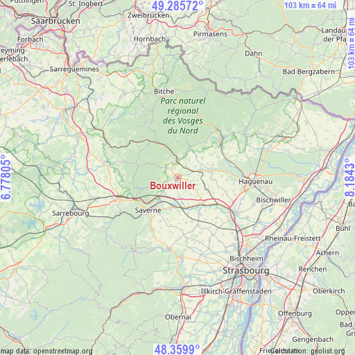
Bouxwiller GPS coordinates[2]
48° 49' 29.82" North, 7° 28' 52.212" East
| Map corner | latitude | longitude |
|---|---|---|
| Upper-left | 49.28572°, | 6.77805° |
| Center: | 48.82495°, | 7.48117° |
| Lower-right: | 48.3599°, | 8.1843° |
| Map W x H: | 102.9×102.9 km | = 63.9×63.9mi |
| max Lat: | 51.07786° ⇑23.9% North |
| Bouxwiller: | 48.82495° |
| min Lat: | ⇓76.1% South 41.3874° |
| min Long | Bouxwiller | max Long |
| -5.08615° | 7.48117° | 9.52242° |
| W 97.8%⇐ | ⇒2.2% E |
Elevation
Elevation of Bouxwiller is 226 m = 741 ft, and this is 32.3 m = 106 ft above average elevation for this country.
| Max E: |
2333 m = 7654 ft | 28.6% |
| Bouxwiller | 226 m 741 ft | |
| Avg. | 193.7 m = 635 ft | |
Min E: |
-1 m = -3 ft | 71.4% |
See also: France elevation on elevation.city.
Geographical zone
Bouxwiller is located in North temperate zone (between Tropic of Cancer and the Arctic Circle). Distance of this North polar circle is 1972.3 km =1225.5 mi to North.| Distance of | km | miles | from Bouxwiller |
|---|---|---|---|
| North Pole | 4578.2 | 2844.8 | to North |
| Arctic Circle | 1972.3 | 1225.5 | to North |
| Tropic Cancer | 2822.9 | 1754.1 | to South |
| Equator | 5428.8 | 3373.3 | to South |


Nearby cities:
15 places around Bouxwiller: (largest is in red/bold)
• Bosselshausen
3 km =1.9 mi,  136°
136°
• Dettwiller
7.9 km =4.9 mi,  187°
187°
• Dossenheim-sur-Zinsel
6.1 km =3.8 mi,  249°
249°
• Ernolsheim-lès-Saverne
8.2 km =5.1 mi,  243°
243°
• Ettendorf
7.5 km =4.7 mi,  100°
100°
• Hattmatt
5.8 km =3.6 mi,  228°
228°
• Ingwiller
5.3 km =3.3 mi,  358°
358°
• Melsheim
8.1 km =5 mi,  158°
158°
• Menchhoffen
4 km =2.5 mi,  16°
16°
• Neuwiller-lès-Saverne
5.6 km =3.5 mi,  270°
270°
• Obermodern-Zutzendorf
4.7 km =2.9 mi,  53°
53°
• Steinbourg
7.8 km =4.8 mi,  219°
219°
• Weinbourg
5.9 km =3.7 mi,  330°
330°
• Weiterswiller
6 km =3.7 mi,  302°
302°
• Wilwisheim
8.7 km =5.4 mi,  167°
167°
Sources, notices
• [Note1] Compared only with cities in France existing in our database
• [Src1] Map data: © OpenStreetMap contributors (CC-BY-SA)
• [Src2] Other city data from geonames.org with taken over terms of usage.
• [Src3] Geographical zone / Annual Mean Temperature by Robert A. Rohde @ Wikipedia
