Soliers geodata
Soliers (Normandy) is a populated place; located in France in Europe/Paris (GMT+2) time zone. With population of 1,818 people, there are 5221 cities with bigger population in this country. Compared to other cities in France, 83% of cities are located further ↓South; 80.8% of cities are located further →East and 88.3% of cities have higher elevation than Soliers. Note1
Administrative division(s):
- Level 1: Normandy
- Level 2: Calvados
- Level 3: Arrondissement de Caen
- Level 4: Soliers


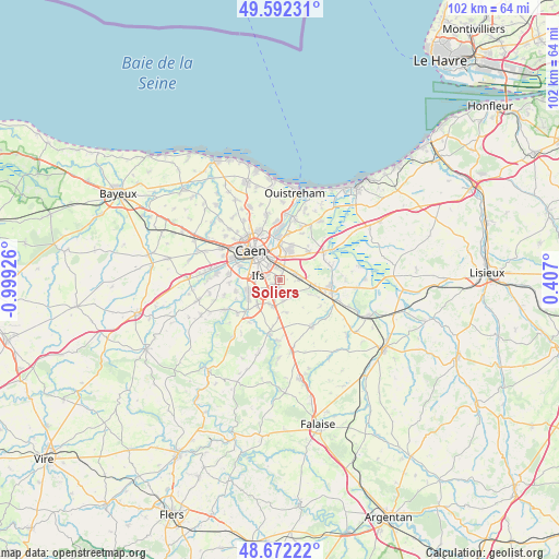
Soliers GPS coordinates[2]
49° 8' 3.84" North, 0° 17' 46.068" West
| Map corner | latitude | longitude |
|---|---|---|
| Upper-left | 49.59231°, | -0.99926° |
| Center: | 49.1344°, | -0.29613° |
| Lower-right: | 48.67222°, | 0.407° |
| Map W x H: | 102.3×102.3 km | = 63.6×63.6mi |
| max Lat: | 51.07786° ⇑17% North |
| Soliers: | 49.1344° |
| min Lat: | ⇓83% South 41.3874° |
| min Long | Soliers | max Long |
| -5.08615° | -0.29613° | 9.52242° |
| W 19.2%⇐ | ⇒80.8% E |
Elevation
Elevation of Soliers is 34 m = 112 ft, and this is 159.7 m = 524 ft below average elevation for this country.
| Max E: |
2333 m = 7654 ft | 88.3% |
| Avg. | 193.7 m = 635 ft | |
| Soliers | 34 m = 112 ft | |
Min E: |
-1 m = -3 ft | 11.7% |
See also: France elevation on elevation.city.
Geographical zone
Soliers is located in North temperate zone (between Tropic of Cancer and the Arctic Circle). Distance of this North polar circle is 1937.9 km =1204.2 mi to North.| Distance of | km | miles | from Soliers |
|---|---|---|---|
| North Pole | 4543.8 | 2823.4 | to North |
| Arctic Circle | 1937.9 | 1204.2 | to North |
| Tropic Cancer | 2857.3 | 1775.4 | to South |
| Equator | 5463.2 | 3394.7 | to South |


Nearby cities:
15 places around Soliers: (largest is in red/bold)
• Bellengreville
6.4 km =4 mi,  100°
100°
• Bourguébus
1.4 km =0.9 mi,  185°
185°
• Cagny
3.2 km =2 mi,  66°
66°
• Chicheboville
6.5 km =4 mi,  115°
115°
• Cormelles-le-Royal
3.3 km =2.1 mi,  310°
310°
• Démouville
5.4 km =3.4 mi,  20°
20°
• Fleury-sur-Orne
6 km =3.7 mi,  285°
285°
• Fontenay-le-Marmion
6.1 km =3.8 mi,  222°
222°
• Garcelles-Secqueville
4 km =2.5 mi,  173°
173°
• Giberville
5.3 km =3.3 mi,  9°
9°
• Grentheville
1.6 km =1 mi, 23°
• Ifs
3.9 km =2.4 mi,  279°
279°
• Mondeville
4.9 km =3 mi,  337°
337°
• Rocquancourt
4.9 km =3 mi,  202°
202°
• Saint-Martin-de-Fontenay
6 km =3.7 mi,  249°
249°
Sources, notices
• [Note1] Compared only with cities in France existing in our database
• [Src1] Map data: © OpenStreetMap contributors (CC-BY-SA)
• [Src2] Other city data from geonames.org with taken over terms of usage.
• [Src3] Geographical zone / Annual Mean Temperature by Robert A. Rohde @ Wikipedia
