Garcelles-Secqueville geodata
Garcelles-Secqueville (Normandy) is a populated place; located in France in Europe/Paris (GMT+2) time zone. With population of 525 people, there are 14719 cities with bigger population in this country. Compared to other cities in France, 82.1% of cities are located further ↓South; 80.7% of cities are located further →East and 69.7% of cities have higher elevation than Garcelles-Secqueville. Note1
Administrative division(s):
- Level 1: Normandy
- Level 2: Calvados
- Level 3: Arrondissement de Caen
- Level 4: Le Castelet


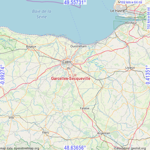
Garcelles-Secqueville GPS coordinates[2]
49° 5' 56.652" North, 0° 17' 22.596" West
| Map corner | latitude | longitude |
|---|---|---|
| Upper-left | 49.55731°, | -0.99274° |
| Center: | 49.09907°, | -0.28961° |
| Lower-right: | 48.63656°, | 0.41351° |
| Map W x H: | 102.4×102.4 km | = 63.6×63.6mi |
| max Lat: | 51.07786° ⇑17.9% North |
| Garcelles-Secqueville: | 49.09907° |
| min Lat: | ⇓82.1% South 41.3874° |
| min Long | Garcelles-Secqu | max Long |
| -5.08615° | -0.28961° | 9.52242° |
| W 19.3%⇐ | ⇒80.7% E |
Elevation
Elevation of Garcelles-Secqueville is 79 m = 259 ft, and this is 114.7 m = 376 ft below average elevation for this country.
| Max E: |
2333 m = 7654 ft | 69.7% |
| Avg. | 193.7 m = 635 ft | |
| Garcelles-Secqueville | 79 m = 259 ft | |
Min E: |
-1 m = -3 ft | 30.3% |
See also: France elevation on elevation.city.
Geographical zone
Garcelles-Secqueville is located in North temperate zone (between Tropic of Cancer and the Arctic Circle). Distance of this North polar circle is 1941.9 km =1206.6 mi to North.| Distance of | km | miles | from Garcelles-Secqueville |
|---|---|---|---|
| North Pole | 4547.8 | 2825.9 | to North |
| Arctic Circle | 1941.9 | 1206.6 | to North |
| Tropic Cancer | 2853.4 | 1773 | to South |
| Equator | 5459.3 | 3392.3 | to South |


Nearby cities:
15 places around Garcelles-Secqueville: (largest is in red/bold)
• Bellengreville
6.5 km =4 mi,  64°
64°
• Bourguébus
2.6 km =1.6 mi,  346°
346°
• Bretteville-sur-Laize
6.6 km =4.1 mi,  203°
203°
• Cagny
5.7 km =3.5 mi,  25°
25°
• Chicheboville
5.6 km =3.5 mi,  77°
77°
• Cormelles-le-Royal
6.8 km =4.2 mi,  333°
333°
• Fontenay-le-Marmion
4.7 km =2.9 mi,  262°
262°
• Grentheville
5.4 km =3.4 mi,  1°
1°
• Ifs
6.3 km =3.9 mi,  316°
316°
• May-sur-Orne
6.2 km =3.9 mi,  272°
272°
• Rocquancourt
2.4 km =1.5 mi, 255°
• Saint-André-sur-Orne
7 km =4.3 mi,  286°
286°
• Saint-Martin-de-Fontenay
6.4 km =4 mi, 286°
• Soliers
4 km =2.5 mi, 353°
• Vimont
7.1 km =4.4 mi,  68°
68°
Sources, notices
• [Note1] Compared only with cities in France existing in our database
• [Src1] Map data: © OpenStreetMap contributors (CC-BY-SA)
• [Src2] Other city data from geonames.org with taken over terms of usage.
• [Src3] Geographical zone / Annual Mean Temperature by Robert A. Rohde @ Wikipedia
