Fontenay-le-Marmion geodata
Fontenay-le-Marmion (Normandy) is a populated place; located in France in Europe/Paris (GMT+2) time zone. With population of 1,530 people, there are 6080 cities with bigger population in this country. Compared to other cities in France, 82% of cities are located further ↓South; 81.4% of cities are located further →East and 80.6% of cities have higher elevation than Fontenay-le-Marmion. Note1
Administrative division(s):
- Level 1: Normandy
- Level 2: Calvados
- Level 3: Arrondissement de Caen
- Level 4: Fontenay-le-Marmion


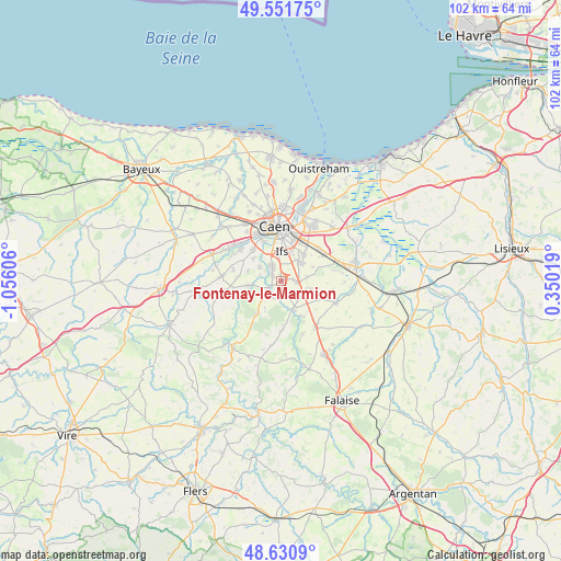
Fontenay-le-Marmion GPS coordinates[2]
49° 5' 36.456" North, 0° 21' 10.584" West
| Map corner | latitude | longitude |
|---|---|---|
| Upper-left | 49.55175°, | -1.05606° |
| Center: | 49.09346°, | -0.35294° |
| Lower-right: | 48.6309°, | 0.35019° |
| Map W x H: | 102.4×102.4 km | = 63.6×63.6mi |
| max Lat: | 51.07786° ⇑18% North |
| Fontenay-le-Marmion: | 49.09346° |
| min Lat: | ⇓82% South 41.3874° |
| min Long | Fontenay-le-Mar | max Long |
| -5.08615° | -0.35294° | 9.52242° |
| W 18.6%⇐ | ⇒81.4% E |
Elevation
Elevation of Fontenay-le-Marmion is 53 m = 174 ft, and this is 140.7 m = 462 ft below average elevation for this country.
| Max E: |
2333 m = 7654 ft | 80.6% |
| Avg. | 193.7 m = 635 ft | |
| Fontenay-le-Marmion | 53 m = 174 ft | |
Min E: |
-1 m = -3 ft | 19.4% |
See also: France elevation on elevation.city.
Geographical zone
Fontenay-le-Marmion is located in North temperate zone (between Tropic of Cancer and the Arctic Circle). Distance of this North polar circle is 1942.5 km =1207 mi to North.| Distance of | km | miles | from Fontenay-le-Marmion |
|---|---|---|---|
| North Pole | 4548.4 | 2826.2 | to North |
| Arctic Circle | 1942.5 | 1207 | to North |
| Tropic Cancer | 2852.8 | 1772.6 | to South |
| Equator | 5458.7 | 3391.9 | to South |


Nearby cities:
15 places around Fontenay-le-Marmion: (largest is in red/bold)
• Amayé-sur-Orne
6.3 km =3.9 mi,  261°
261°
• Boulon
5.9 km =3.7 mi,  209°
209°
• Bourguébus
5.1 km =3.2 mi,  51°
51°
• Bretteville-sur-Laize
5.8 km =3.6 mi,  160°
160°
• Bully
4.1 km =2.5 mi,  282°
282°
• Clinchamps-sur-Orne
3.9 km =2.4 mi,  244°
244°
• Fresney-le-Puceux
3.6 km =2.2 mi,  199°
199°
• Garcelles-Secqueville
4.7 km =2.9 mi,  82°
82°
• Ifs
5.2 km =3.2 mi,  3°
3°
• May-sur-Orne
1.8 km =1.1 mi,  298°
298°
• Rocquancourt
2.3 km =1.4 mi,  89°
89°
• Saint-André-sur-Orne
3.4 km =2.1 mi,  321°
321°
• Saint-Martin-de-Fontenay
2.9 km =1.8 mi,  327°
327°
• Soliers
6.1 km =3.8 mi,  42°
42°
• Vieux
6.1 km =3.8 mi, 284°
Sources, notices
• [Note1] Compared only with cities in France existing in our database
• [Src1] Map data: © OpenStreetMap contributors (CC-BY-SA)
• [Src2] Other city data from geonames.org with taken over terms of usage.
• [Src3] Geographical zone / Annual Mean Temperature by Robert A. Rohde @ Wikipedia
