Grentheville geodata
Grentheville (Normandy) is a populated place; located in France in Europe/Paris (GMT+2) time zone. With population of 783 people, there are 10791 cities with bigger population in this country. Compared to other cities in France, 83.3% of cities are located further ↓South; 80.7% of cities are located further →East and 91.6% of cities have higher elevation than Grentheville. Note1
Administrative division(s):
- Level 1: Normandy
- Level 2: Calvados
- Level 3: Arrondissement de Caen
- Level 4: Grentheville


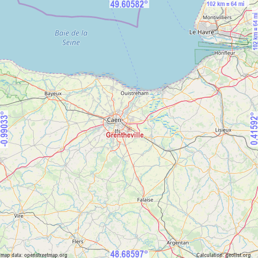
Grentheville GPS coordinates[2]
49° 8' 52.908" North, 0° 17' 13.92" West
| Map corner | latitude | longitude |
|---|---|---|
| Upper-left | 49.60582°, | -0.99033° |
| Center: | 49.14803°, | -0.2872° |
| Lower-right: | 48.68597°, | 0.41592° |
| Map W x H: | 102.3×102.3 km | = 63.6×63.6mi |
| max Lat: | 51.07786° ⇑16.7% North |
| Grentheville: | 49.14803° |
| min Lat: | ⇓83.3% South 41.3874° |
| min Long | Grentheville | max Long |
| -5.08615° | -0.2872° | 9.52242° |
| W 19.3%⇐ | ⇒80.7% E |
Elevation
Elevation of Grentheville is 26 m = 85 ft, and this is 167.7 m = 550 ft below average elevation for this country.
| Max E: |
2333 m = 7654 ft | 91.6% |
| Avg. | 193.7 m = 635 ft | |
| Grentheville | 26 m = 85 ft | |
Min E: |
-1 m = -3 ft | 8.4% |
See also: France elevation on elevation.city.
Geographical zone
Grentheville is located in North temperate zone (between Tropic of Cancer and the Arctic Circle). Distance of this North polar circle is 1936.4 km =1203.2 mi to North.| Distance of | km | miles | from Grentheville |
|---|---|---|---|
| North Pole | 4542.3 | 2822.5 | to North |
| Arctic Circle | 1936.4 | 1203.2 | to North |
| Tropic Cancer | 2858.8 | 1776.4 | to South |
| Equator | 5464.7 | 3395.6 | to South |


Nearby cities:
15 places around Grentheville: (largest is in red/bold)
• Bellengreville
6.2 km =3.9 mi,  115°
115°
• Bourguébus
3 km =1.9 mi,  194°
194°
• Cagny
2.3 km =1.4 mi,  96°
96°
• Colombelles
6.4 km =4 mi,  354°
354°
• Cormelles-le-Royal
3.2 km =2 mi,  281°
281°
• Cuverville
4.9 km =3 mi,  19°
19°
• Démouville
3.8 km =2.4 mi, 19°
• Fleury-sur-Orne
6.4 km =4 mi,  270°
270°
• Garcelles-Secqueville
5.4 km =3.4 mi,  181°
181°
• Giberville
3.7 km =2.3 mi,  3°
3°
• Ifs
4.6 km =2.9 mi,  258°
258°
• Mondeville
3.9 km =2.4 mi,  319°
319°
• Rocquancourt
6.5 km =4 mi,  202°
202°
• Sannerville
5.8 km =3.6 mi,  51°
51°
• Soliers
1.6 km =1 mi, 203°
Sources, notices
• [Note1] Compared only with cities in France existing in our database
• [Src1] Map data: © OpenStreetMap contributors (CC-BY-SA)
• [Src2] Other city data from geonames.org with taken over terms of usage.
• [Src3] Geographical zone / Annual Mean Temperature by Robert A. Rohde @ Wikipedia
