Soleymieu geodata
Soleymieu (Auvergne-Rhône-Alpes) is a populated place; located in France in Europe/Paris (GMT+2) time zone. With population of 619 people, there are 13004 cities with bigger population in this country. Compared to other cities in France, 70.8% of cities are located further ↑North; 81.1% of cities are located further ←West and 82.2% of cities have lower elevation than Soleymieu. Note1
Administrative division(s):
- Level 1: Auvergne-Rhône-Alpes
- Level 2: Département de l'Isère
- Level 3: Arrondissement de La Tour-du-Pin
- Level 4: Soleymieu


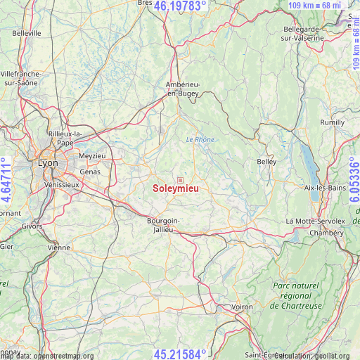
Soleymieu GPS coordinates[2]
45° 42' 32.364" North, 5° 21' 0.828" East
| Map corner | latitude | longitude |
|---|---|---|
| Upper-left | 46.19783°, | 4.64711° |
| Center: | 45.70899°, | 5.35023° |
| Lower-right: | 45.21584°, | 6.05336° |
| Map W x H: | 109.2×109.2 km | = 67.9×67.9mi |
| max Lat: | 51.07786° ⇑70.8% North |
| Soleymieu: | 45.70899° |
| min Lat: | ⇓29.2% South 41.3874° |
| min Long | Soleymieu | max Long |
| -5.08615° | 5.35023° | 9.52242° |
| W 81.1%⇐ | ⇒18.9% E |
Elevation
Elevation of Soleymieu is 312 m = 1024 ft, and this is 118.3 m = 388 ft above average elevation for this country.
| Max E: |
2333 m = 7654 ft | 17.8% |
| Soleymieu | 312 m 1024 ft | |
| Avg. | 193.7 m = 635 ft | |
Min E: |
-1 m = -3 ft | 82.2% |
See also: France elevation on elevation.city.
Geographical zone
Soleymieu is located in North temperate zone (between Tropic of Cancer and the Arctic Circle). Distance of this North polar circle is 2318.8 km =1440.8 mi to North.| Distance of | km | miles | from Soleymieu |
|---|---|---|---|
| North Pole | 4924.7 | 3060.1 | to North |
| Arctic Circle | 2318.8 | 1440.8 | to North |
| Tropic Cancer | 2476.4 | 1538.8 | to South |
| Equator | 5082.4 | 3158.1 | to South |


Nearby cities:
15 places around Soleymieu: (largest is in red/bold)
• Annoisin
7 km =4.3 mi,  319°
319°
• Courtenay
3.2 km =2 mi,  48°
48°
• Crémieu
8.1 km =5 mi,  283°
283°
• Dizimieu
4.4 km =2.7 mi, 284°
• Leyrieu
9.2 km =5.7 mi,  307°
307°
• Morestel
9.5 km =5.9 mi,  110°
110°
• Optevoz
5.2 km =3.2 mi,  343°
343°
• Passins
6.6 km =4.1 mi, 110°
• Saint-Baudille-de-la-Tour
8.8 km =5.5 mi,  354°
354°
• Saint-Chef
8.2 km =5.1 mi,  172°
172°
• Saint-Savin
9.6 km =6 mi,  199°
199°
• Salagnon
4.6 km =2.9 mi, 167°
• Sermérieu
6.4 km =4 mi,  132°
132°
• Siccieu
3.9 km =2.4 mi, 319°
• Trept
3.4 km =2.1 mi,  225°
225°
Sources, notices
• [Note1] Compared only with cities in France existing in our database
• [Src1] Map data: © OpenStreetMap contributors (CC-BY-SA)
• [Src2] Other city data from geonames.org with taken over terms of usage.
• [Src3] Geographical zone / Annual Mean Temperature by Robert A. Rohde @ Wikipedia
