Passins geodata
Passins (Auvergne-Rhône-Alpes) is a populated place; located in France in Europe/Paris (GMT+2) time zone. With population of 758 people, there are 11078 cities with bigger population in this country. Compared to other cities in France, 71.1% of cities are located further ↑North; 82.3% of cities are located further ←West and 77.2% of cities have lower elevation than Passins. Note1
Administrative division(s):
- Level 1: Auvergne-Rhône-Alpes
- Level 2: Département de l'Isère
- Level 3: Arrondissement de La Tour-du-Pin
- Level 4: Arandon-Passins


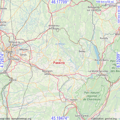
Passins GPS coordinates[2]
45° 41' 17.052" North, 5° 25' 47.532" East
| Map corner | latitude | longitude |
|---|---|---|
| Upper-left | 46.17709°, | 4.72674° |
| Center: | 45.68807°, | 5.42987° |
| Lower-right: | 45.19474°, | 6.13299° |
| Map W x H: | 109.2×109.2 km | = 67.9×67.9mi |
| max Lat: | 51.07786° ⇑71.1% North |
| Passins: | 45.68807° |
| min Lat: | ⇓28.9% South 41.3874° |
| min Long | Passins | max Long |
| -5.08615° | 5.42987° | 9.52242° |
| W 82.3%⇐ | ⇒17.7% E |
Elevation
Elevation of Passins is 265 m = 869 ft, and this is 71.3 m = 234 ft above average elevation for this country.
| Max E: |
2333 m = 7654 ft | 22.8% |
| Passins | 265 m 869 ft | |
| Avg. | 193.7 m = 635 ft | |
Min E: |
-1 m = -3 ft | 77.2% |
See also: France elevation on elevation.city.
Geographical zone
Passins is located in North temperate zone (between Tropic of Cancer and the Arctic Circle). Distance of this North polar circle is 2321.1 km =1442.3 mi to North.| Distance of | km | miles | from Passins |
|---|---|---|---|
| North Pole | 4927 | 3061.5 | to North |
| Arctic Circle | 2321.1 | 1442.3 | to North |
| Tropic Cancer | 2474.1 | 1537.3 | to South |
| Equator | 5080 | 3156.6 | to South |


Nearby cities:
15 places around Passins: (largest is in red/bold)
• Brangues
7.9 km =4.9 mi,  85°
85°
• Courtenay
5.9 km =3.7 mi,  319°
319°
• Creys-Mépieu
6.5 km =4 mi,  39°
39°
• Curtin
6.8 km =4.2 mi,  136°
136°
• Le Bouchage
7.3 km =4.5 mi,  103°
103°
• Morestel
2.9 km =1.8 mi,  110°
110°
• Saint-Chef
7.7 km =4.8 mi,  221°
221°
• Saint-Sorlin-de-Morestel
6.9 km =4.3 mi,  145°
145°
• Saint-Victor-de-Morestel
5.6 km =3.5 mi,  76°
76°
• Salagnon
5.6 km =3.5 mi,  247°
247°
• Sermérieu
2.5 km =1.6 mi, 215°
• Soleymieu
6.6 km =4.1 mi,  290°
290°
• Thuellin
8.1 km =5 mi,  131°
131°
• Trept
8.7 km =5.4 mi,  269°
269°
• Vignieu
6 km =3.7 mi,  182°
182°
Sources, notices
• [Note1] Compared only with cities in France existing in our database
• [Src1] Map data: © OpenStreetMap contributors (CC-BY-SA)
• [Src2] Other city data from geonames.org with taken over terms of usage.
• [Src3] Geographical zone / Annual Mean Temperature by Robert A. Rohde @ Wikipedia
