Saint-Savin geodata
Saint-Savin (Auvergne-Rhône-Alpes) is a populated place; located in France in Europe/Paris (GMT+2) time zone. With population of 3,035 people, there are 3209 cities with bigger population in this country. Compared to other cities in France, 72.1% of cities are located further ↑North; 80.7% of cities are located further ←West and 76.7% of cities have lower elevation than Saint-Savin. Note1
Administrative division(s):
- Level 1: Auvergne-Rhône-Alpes
- Level 2: Département de l'Isère
- Level 3: Arrondissement de La Tour-du-Pin
- Level 4: Saint-Savin


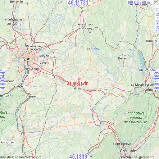
Saint-Savin GPS coordinates[2]
45° 37' 39.936" North, 5° 18' 30.816" East
| Map corner | latitude | longitude |
|---|---|---|
| Upper-left | 46.11731°, | 4.60544° |
| Center: | 45.62776°, | 5.30856° |
| Lower-right: | 45.1339°, | 6.01169° |
| Map W x H: | 109.3×109.3 km | = 67.9×67.9mi |
| max Lat: | 51.07786° ⇑72.1% North |
| Saint-Savin: | 45.62776° |
| min Lat: | ⇓27.9% South 41.3874° |
| min Long | Saint-Savin | max Long |
| -5.08615° | 5.30856° | 9.52242° |
| W 80.7%⇐ | ⇒19.3% E |
Elevation
Elevation of Saint-Savin is 261 m = 856 ft, and this is 67.3 m = 221 ft above average elevation for this country.
| Max E: |
2333 m = 7654 ft | 23.3% |
| Saint-Savin | 261 m 856 ft | |
| Avg. | 193.7 m = 635 ft | |
Min E: |
-1 m = -3 ft | 76.7% |
See also: France elevation on elevation.city.
Geographical zone
Saint-Savin is located in North temperate zone (between Tropic of Cancer and the Arctic Circle). Distance of this North polar circle is 2327.8 km =1446.4 mi to North.| Distance of | km | miles | from Saint-Savin |
|---|---|---|---|
| North Pole | 4933.7 | 3065.7 | to North |
| Arctic Circle | 2327.8 | 1446.4 | to North |
| Tropic Cancer | 2467.4 | 1533.2 | to South |
| Equator | 5073.3 | 3152.4 | to South |


Nearby cities:
15 places around Saint-Savin: (largest is in red/bold)
• Bourgoin-Jallieu
5.4 km =3.4 mi,  210°
210°
• Cessieu
8.8 km =5.5 mi,  143°
143°
• Domarin
6.7 km =4.2 mi,  226°
226°
• Frontonas
8.9 km =5.5 mi,  282°
282°
• L’Isle-d’Abeau
6.6 km =4.1 mi,  262°
262°
• Maubec
7.6 km =4.7 mi, 207°
• Meyrié
7.9 km =4.9 mi,  191°
191°
• Nivolas-Vermelle
7.7 km =4.8 mi,  181°
181°
• Ruy
4.7 km =2.9 mi,  167°
167°
• Saint-Alban-de-Roche
7.4 km =4.6 mi,  240°
240°
• Saint-Chef
4.5 km =2.8 mi,  78°
78°
• Salagnon
6.2 km =3.9 mi,  43°
43°
• Sermérieu
9.2 km =5.7 mi,  59°
59°
• Sérézin-de-la-Tour
8.5 km =5.3 mi,  159°
159°
• Trept
6.7 km =4.2 mi,  6°
6°
Sources, notices
• [Note1] Compared only with cities in France existing in our database
• [Src1] Map data: © OpenStreetMap contributors (CC-BY-SA)
• [Src2] Other city data from geonames.org with taken over terms of usage.
• [Src3] Geographical zone / Annual Mean Temperature by Robert A. Rohde @ Wikipedia
