West-Cappel geodata
West-Cappel (Hauts-de-France) is a populated place; located in France in Europe/Paris (GMT+2) time zone. With population of 544 people, there are 14318 cities with bigger population in this country. Compared to other cities in France, 99.7% of cities are located further ↓South; 50.7% of cities are located further ←West and 92.7% of cities have higher elevation than West-Cappel. Note1
Administrative division(s):
- Level 1: Hauts-de-France
- Level 2: Nord
- Level 3: Arrondissement de Dunkerque
- Level 4: West-Cappel


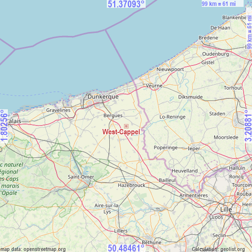
West-Cappel GPS coordinates[2]
50° 55' 47.568" North, 2° 30' 20.448" East
| Map corner | latitude | longitude |
|---|---|---|
| Upper-left | 51.37093°, | 1.80256° |
| Center: | 50.92988°, | 2.50568° |
| Lower-right: | 50.48461°, | 3.20881° |
| Map W x H: | 98.5×98.5 km | = 61.2×61.2mi |
| max Lat: | 51.07786° ⇑0.3% North |
| West-Cappel: | 50.92988° |
| min Lat: | ⇓99.7% South 41.3874° |
| min Long | West-Cappel | max Long |
| -5.08615° | 2.50568° | 9.52242° |
| W 50.7%⇐ | ⇒49.3% E |
Elevation
Elevation of West-Cappel is 23 m = 75 ft, and this is 170.7 m = 560 ft below average elevation for this country.
| Max E: |
2333 m = 7654 ft | 92.7% |
| Avg. | 193.7 m = 635 ft | |
| West-Cappel | 23 m = 75 ft | |
Min E: |
-1 m = -3 ft | 7.3% |
See also: France elevation on elevation.city.
Geographical zone
West-Cappel is located in North temperate zone (between Tropic of Cancer and the Arctic Circle). Distance of this North polar circle is 1738.3 km =1080.1 mi to North.| Distance of | km | miles | from West-Cappel |
|---|---|---|---|
| North Pole | 4344.2 | 2699.4 | to North |
| Arctic Circle | 1738.3 | 1080.1 | to North |
| Tropic Cancer | 3057 | 1899.5 | to South |
| Equator | 5662.9 | 3518.8 | to South |


Nearby cities:
15 places around West-Cappel: (largest is in red/bold)
• Bambecque
4.3 km =2.7 mi,  136°
136°
• Bergues
6.7 km =4.2 mi,  310°
310°
• Bierne
7.6 km =4.7 mi,  298°
298°
• Crochte
8.3 km =5.2 mi,  274°
274°
• Esquelbecq
7 km =4.3 mi,  227°
227°
• Herzeele
5.3 km =3.3 mi,  157°
157°
• Hondschoote
7.6 km =4.7 mi,  45°
45°
• Houtkerque
8.6 km =5.3 mi,  132°
132°
• Hoymille
6.2 km =3.9 mi,  318°
318°
• Killem
4.9 km =3 mi, 51°
• Quaëdypre
3.6 km =2.2 mi,  279°
279°
• Rexpoëde
2.6 km =1.6 mi,  66°
66°
• Socx
5.7 km =3.5 mi, 276°
• Warhem
5.2 km =3.2 mi,  350°
350°
• Wormhout
6 km =3.7 mi,  205°
205°
Sources, notices
• [Note1] Compared only with cities in France existing in our database
• [Src1] Map data: © OpenStreetMap contributors (CC-BY-SA)
• [Src2] Other city data from geonames.org with taken over terms of usage.
• [Src3] Geographical zone / Annual Mean Temperature by Robert A. Rohde @ Wikipedia
