Sexey-aux-Forges geodata
Sexey-aux-Forges (Grand Est) is a populated place; located in France in Europe/Paris (GMT+2) time zone. With population of 619 people, there are 13004 cities with bigger population in this country. Compared to other cities in France, 71.4% of cities are located further ↓South; 87.6% of cities are located further ←West and 71% of cities have lower elevation than Sexey-aux-Forges. Note1
Administrative division(s):
- Level 1: Grand Est
- Level 2: Meurthe-et-Moselle
- Level 3: Arrondissement de Toul
- Level 4: Sexey-aux-Forges


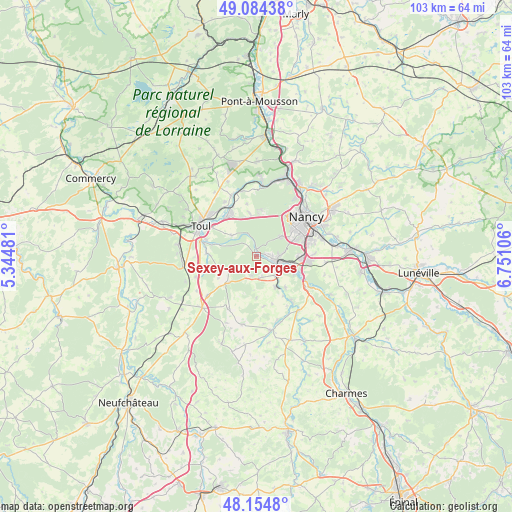
Sexey-aux-Forges GPS coordinates[2]
48° 37' 18.228" North, 6° 2' 52.548" East
| Map corner | latitude | longitude |
|---|---|---|
| Upper-left | 49.08438°, | 5.34481° |
| Center: | 48.62173°, | 6.04793° |
| Lower-right: | 48.1548°, | 6.75106° |
| Map W x H: | 103.4×103.4 km | = 64.2×64.2mi |
| max Lat: | 51.07786° ⇑28.6% North |
| Sexey-aux-Forges: | 48.62173° |
| min Lat: | ⇓71.4% South 41.3874° |
| min Long | Sexey-aux-Forge | max Long |
| -5.08615° | 6.04793° | 9.52242° |
| W 87.6%⇐ | ⇒12.4% E |
Elevation
Elevation of Sexey-aux-Forges is 224 m = 735 ft, and this is 30.3 m = 99 ft above average elevation for this country.
| Max E: |
2333 m = 7654 ft | 29% |
| Sexey-aux-Forges | 224 m 735 ft | |
| Avg. | 193.7 m = 635 ft | |
Min E: |
-1 m = -3 ft | 71% |
See also: France elevation on elevation.city.
Geographical zone
Sexey-aux-Forges is located in North temperate zone (between Tropic of Cancer and the Arctic Circle). Distance of this North polar circle is 1994.9 km =1239.6 mi to North.| Distance of | km | miles | from Sexey-aux-Forges |
|---|---|---|---|
| North Pole | 4600.8 | 2858.8 | to North |
| Arctic Circle | 1994.9 | 1239.6 | to North |
| Tropic Cancer | 2800.3 | 1740 | to South |
| Equator | 5406.2 | 3359.3 | to South |


Nearby cities:
15 places around Sexey-aux-Forges: (largest is in red/bold)
• Bainville-sur-Madon
5.2 km =3.2 mi,  137°
137°
• Chaligny
2.6 km =1.6 mi,  83°
83°
• Chavigny
5.6 km =3.5 mi, 81°
• Frolois
8.5 km =5.3 mi, 137°
• Ludres
8.8 km =5.5 mi,  91°
91°
• Maizières
4.4 km =2.7 mi,  168°
168°
• Messein
6.8 km =4.2 mi,  99°
99°
• Méréville
8.3 km =5.2 mi,  114°
114°
• Neuves-Maisons
4.2 km =2.6 mi, 95°
• Pierre-la-Treiche
8.7 km =5.4 mi,  285°
285°
• Pont-Saint-Vincent
4.1 km =2.5 mi,  116°
116°
• Thuilley-aux-Groseilles
7.6 km =4.7 mi,  226°
226°
• Velaine-en-Haye
8.8 km =5.5 mi,  350°
350°
• Viterne
4 km =2.5 mi,  199°
199°
• Xeuilley
7.2 km =4.5 mi,  148°
148°
Sources, notices
• [Note1] Compared only with cities in France existing in our database
• [Src1] Map data: © OpenStreetMap contributors (CC-BY-SA)
• [Src2] Other city data from geonames.org with taken over terms of usage.
• [Src3] Geographical zone / Annual Mean Temperature by Robert A. Rohde @ Wikipedia
