Velaine-en-Haye geodata
Velaine-en-Haye (Grand Est) is a populated place; located in France in Europe/Paris (GMT+2) time zone. With population of 1,494 people, there are 6209 cities with bigger population in this country. Compared to other cities in France, 73.2% of cities are located further ↓South; 87.3% of cities are located further ←West and 79.8% of cities have lower elevation than Velaine-en-Haye. Note1
Administrative division(s):
- Level 1: Grand Est
- Level 2: Meurthe-et-Moselle
- Level 3: Arrondissement de Toul
- Level 4: Bois-de-Haye


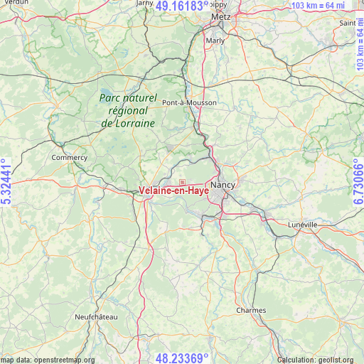
Velaine-en-Haye GPS coordinates[2]
48° 41' 59.64" North, 6° 1' 39.144" East
| Map corner | latitude | longitude |
|---|---|---|
| Upper-left | 49.16183°, | 5.32441° |
| Center: | 48.6999°, | 6.02754° |
| Lower-right: | 48.23369°, | 6.73066° |
| Map W x H: | 103.2×103.2 km | = 64.1×64.1mi |
| max Lat: | 51.07786° ⇑26.8% North |
| Velaine-en-Haye: | 48.6999° |
| min Lat: | ⇓73.2% South 41.3874° |
| min Long | Velaine-en-Haye | max Long |
| -5.08615° | 6.02754° | 9.52242° |
| W 87.3%⇐ | ⇒12.7% E |
Elevation
Elevation of Velaine-en-Haye is 288 m = 945 ft, and this is 94.3 m = 309 ft above average elevation for this country.
| Max E: |
2333 m = 7654 ft | 20.2% |
| Velaine-en-Haye | 288 m 945 ft | |
| Avg. | 193.7 m = 635 ft | |
Min E: |
-1 m = -3 ft | 79.8% |
See also: France elevation on elevation.city.
Geographical zone
Velaine-en-Haye is located in North temperate zone (between Tropic of Cancer and the Arctic Circle). Distance of this North polar circle is 1986.3 km =1234.2 mi to North.| Distance of | km | miles | from Velaine-en-Haye |
|---|---|---|---|
| North Pole | 4592.1 | 2853.4 | to North |
| Arctic Circle | 1986.3 | 1234.2 | to North |
| Tropic Cancer | 2809 | 1745.4 | to South |
| Equator | 5414.9 | 3364.7 | to South |


Nearby cities:
15 places around Velaine-en-Haye: (largest is in red/bold)
• Aingeray
4.7 km =2.9 mi,  336°
336°
• Chaligny
9.3 km =5.8 mi,  154°
154°
• Chaudeney-sur-Moselle
10.3 km =6.4 mi,  239°
239°
• Dommartin-lès-Toul
9.3 km =5.8 mi,  248°
248°
• Frouard
10.1 km =6.3 mi,  48°
48°
• Gondreville
4.7 km =2.9 mi,  261°
261°
• Laxou
9.1 km =5.7 mi,  101°
101°
• Liverdun
6.1 km =3.8 mi,  25°
25°
• Maxéville
10.3 km =6.4 mi,  81°
81°
• Pierre-la-Treiche
9.3 km =5.8 mi,  227°
227°
• Saizerais
10.4 km =6.5 mi,  6°
6°
• Sexey-aux-Forges
8.8 km =5.5 mi,  170°
170°
• Toul
10.2 km =6.3 mi, 257°
• Villers-lès-Nancy
9.7 km =6 mi,  107°
107°
• Villey-Saint-Étienne
5.1 km =3.2 mi,  315°
315°
Sources, notices
• [Note1] Compared only with cities in France existing in our database
• [Src1] Map data: © OpenStreetMap contributors (CC-BY-SA)
• [Src2] Other city data from geonames.org with taken over terms of usage.
• [Src3] Geographical zone / Annual Mean Temperature by Robert A. Rohde @ Wikipedia
