Sevelinges geodata
Sevelinges (Auvergne-Rhône-Alpes) is a populated place; located in France in Europe/Paris (GMT+2) time zone. With population of 595 people, there are 13406 cities with bigger population in this country. Compared to other cities in France, 65.1% of cities are located further ↑North; 70.5% of cities are located further ←West and 94.5% of cities have lower elevation than Sevelinges. Note1
Administrative division(s):
- Level 1: Auvergne-Rhône-Alpes
- Level 2: Département de la Loire
- Level 3: Arrondissement de Roanne
- Level 4: Sevelinges


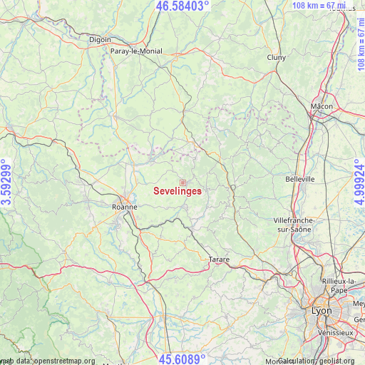
Sevelinges GPS coordinates[2]
46° 5' 55.032" North, 4° 17' 45.996" East
| Map corner | latitude | longitude |
|---|---|---|
| Upper-left | 46.58403°, | 3.59299° |
| Center: | 46.09862°, | 4.29611° |
| Lower-right: | 45.6089°, | 4.99924° |
| Map W x H: | 108.4×108.4 km | = 67.4×67.4mi |
| max Lat: | 51.07786° ⇑65.1% North |
| Sevelinges: | 46.09862° |
| min Lat: | ⇓34.9% South 41.3874° |
| min Long | Sevelinges | max Long |
| -5.08615° | 4.29611° | 9.52242° |
| W 70.5%⇐ | ⇒29.5% E |
Elevation
Elevation of Sevelinges is 560 m = 1837 ft, and this is 366.3 m = 1202 ft above average elevation for this country.
| Max E: |
2333 m = 7654 ft | 5.5% |
| Sevelinges | 560 m 1837 ft | |
| Avg. | 193.7 m = 635 ft | |
Min E: |
-1 m = -3 ft | 94.5% |
See also: France elevation on elevation.city.
Geographical zone
Sevelinges is located in North temperate zone (between Tropic of Cancer and the Arctic Circle). Distance of this North polar circle is 2275.5 km =1413.9 mi to North.| Distance of | km | miles | from Sevelinges |
|---|---|---|---|
| North Pole | 4881.4 | 3033.2 | to North |
| Arctic Circle | 2275.5 | 1413.9 | to North |
| Tropic Cancer | 2519.8 | 1565.7 | to South |
| Equator | 5125.7 | 3185 | to South |


Nearby cities:
15 places around Sevelinges: (largest is in red/bold)
• Belmont-de-la-Loire
8.5 km =5.3 mi,  27°
27°
• Bourg-de-Thizy
7.2 km =4.5 mi,  178°
178°
• Chandon
8.5 km =5.3 mi,  311°
311°
• Coublanc
8.6 km =5.3 mi,  348°
348°
• Cours-la-Ville
1.6 km =1 mi,  84°
84°
• Coutouvre
7.6 km =4.7 mi,  247°
247°
• Cuinzier
3.9 km =2.4 mi,  325°
325°
• La Gresle
2.6 km =1.6 mi,  199°
199°
• Le Cergne
2.8 km =1.7 mi,  22°
22°
• Mardore
4.5 km =2.8 mi,  134°
134°
• Marnand
7.5 km =4.7 mi,  160°
160°
• Mars
7.2 km =4.5 mi, 326°
• Pont-Trambouze
3.3 km =2.1 mi, 155°
• Thizy-les-Bourgs
7.7 km =4.8 mi,  170°
170°
• Villers
6.3 km =3.9 mi,  293°
293°
Sources, notices
• [Note1] Compared only with cities in France existing in our database
• [Src1] Map data: © OpenStreetMap contributors (CC-BY-SA)
• [Src2] Other city data from geonames.org with taken over terms of usage.
• [Src3] Geographical zone / Annual Mean Temperature by Robert A. Rohde @ Wikipedia
