Seurre geodata
Seurre (Bourgogne-Franche-Comté) is a populated place; located in France in Europe/Paris (GMT+2) time zone. With population of 2,804 people, there are 3479 cities with bigger population in this country. Compared to other cities in France, 55.3% of cities are located further ↑North; 79.3% of cities are located further ←West and 62.1% of cities have lower elevation than Seurre. Note1
Administrative division(s):
- Level 1: Bourgogne-Franche-Comté
- Level 2: Département de la Côte-d'Or
- Level 3: Arrondissement de Beaune
- Level 4: Seurre


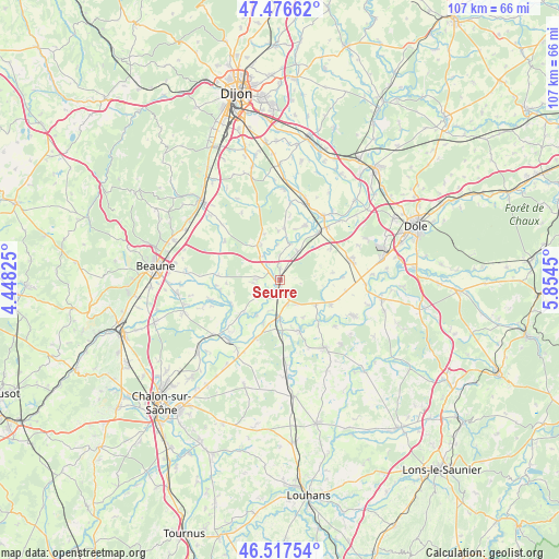
Seurre GPS coordinates[2]
46° 59' 57.228" North, 5° 9' 4.968" East
| Map corner | latitude | longitude |
|---|---|---|
| Upper-left | 47.47662°, | 4.44825° |
| Center: | 46.99923°, | 5.15138° |
| Lower-right: | 46.51754°, | 5.8545° |
| Map W x H: | 106.6×106.6 km | = 66.2×66.2mi |
| max Lat: | 51.07786° ⇑55.3% North |
| Seurre: | 46.99923° |
| min Lat: | ⇓44.7% South 41.3874° |
| min Long | Seurre | max Long |
| -5.08615° | 5.15138° | 9.52242° |
| W 79.3%⇐ | ⇒20.7% E |
Elevation
Elevation of Seurre is 180 m = 591 ft, and this is 13.7 m = 45 ft below average elevation for this country.
| Max E: |
2333 m = 7654 ft | 37.9% |
| Avg. | 193.7 m = 635 ft | |
| Seurre | 180 m = 591 ft | |
Min E: |
-1 m = -3 ft | 62.1% |
See also: France elevation on elevation.city.
Geographical zone
Seurre is located in North temperate zone (between Tropic of Cancer and the Arctic Circle). Distance of this North polar circle is 2175.3 km =1351.7 mi to North.| Distance of | km | miles | from Seurre |
|---|---|---|---|
| North Pole | 4781.2 | 2970.9 | to North |
| Arctic Circle | 2175.3 | 1351.7 | to North |
| Tropic Cancer | 2619.9 | 1627.9 | to South |
| Equator | 5225.8 | 3247.2 | to South |


Nearby cities:
15 places around Seurre: (largest is in red/bold)
• Brazey-en-Plaine
16.2 km =10.1 mi,  17°
17°
• Chamblanc
2.2 km =1.4 mi,  358°
358°
• Ciel
15.4 km =9.6 mi,  212°
212°
• Esbarres
11.7 km =7.3 mi, 24°
• Labergement-lès-Seurre
4.4 km =2.7 mi,  268°
268°
• Losne
13.9 km =8.6 mi,  37°
37°
• Pagny-le-Château
6.3 km =3.9 mi,  31°
31°
• Petit-Noir
15.6 km =9.7 mi,  117°
117°
• Pierre-de-Bresse
14.9 km =9.3 mi,  149°
149°
• Pouilly-sur-Saône
3 km =1.9 mi,  309°
309°
• Saint-Aubin
13.8 km =8.6 mi,  74°
74°
• Saint-Jean-de-Losne
14.4 km =8.9 mi, 36°
• Saint-Usage
14.8 km =9.2 mi, 33°
• Verdun-sur-le-Doubs
15.1 km =9.4 mi,  220°
220°
• Échenon
16.4 km =10.2 mi, 37°
Sources, notices
• [Note1] Compared only with cities in France existing in our database
• [Src1] Map data: © OpenStreetMap contributors (CC-BY-SA)
• [Src2] Other city data from geonames.org with taken over terms of usage.
• [Src3] Geographical zone / Annual Mean Temperature by Robert A. Rohde @ Wikipedia
