Pagny-le-Château geodata
Pagny-le-Château (Bourgogne-Franche-Comté) is a populated place; located in France in Europe/Paris (GMT+2) time zone. With population of 513 people, there are 14965 cities with bigger population in this country. Compared to other cities in France, 54.8% of cities are located further ↑North; 79.7% of cities are located further ←West and 62.4% of cities have lower elevation than Pagny-le-Château. Note1
Administrative division(s):
- Level 1: Bourgogne-Franche-Comté
- Level 2: Département de la Côte-d'Or
- Level 3: Arrondissement de Beaune
- Level 4: Pagny-le-Château


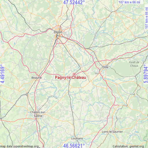
Pagny-le-Château GPS coordinates[2]
47° 2' 50.892" North, 5° 11' 41.352" East
| Map corner | latitude | longitude |
|---|---|---|
| Upper-left | 47.52442°, | 4.49169° |
| Center: | 47.04747°, | 5.19482° |
| Lower-right: | 46.56621°, | 5.89794° |
| Map W x H: | 106.5×106.5 km | = 66.2×66.2mi |
| max Lat: | 51.07786° ⇑54.8% North |
| Pagny-le-Château: | 47.04747° |
| min Lat: | ⇓45.2% South 41.3874° |
| min Long | Pagny-le-Châte | max Long |
| -5.08615° | 5.19482° | 9.52242° |
| W 79.7%⇐ | ⇒20.3% E |
Elevation
Elevation of Pagny-le-Château is 181 m = 594 ft, and this is 12.7 m = 42 ft below average elevation for this country.
| Max E: |
2333 m = 7654 ft | 37.6% |
| Avg. | 193.7 m = 635 ft | |
| Pagny-le-Château | 181 m = 594 ft | |
Min E: |
-1 m = -3 ft | 62.4% |
See also: France elevation on elevation.city.
Geographical zone
Pagny-le-Château is located in North temperate zone (between Tropic of Cancer and the Arctic Circle). Distance of this North polar circle is 2170 km =1348.4 mi to North.| Distance of | km | miles | from Pagny-le-Château |
|---|---|---|---|
| North Pole | 4775.9 | 2967.6 | to North |
| Arctic Circle | 2170 | 1348.4 | to North |
| Tropic Cancer | 2625.3 | 1631.3 | to South |
| Equator | 5231.2 | 3250.5 | to South |


Nearby cities:
15 places around Pagny-le-Château: (largest is in red/bold)
• Abergement-la-Ronce
13.6 km =8.5 mi,  79°
79°
• Aiserey
14.1 km =8.8 mi,  350°
350°
• Brazey-en-Plaine
10.2 km =6.3 mi,  8°
8°
• Chamblanc
4.6 km =2.9 mi,  226°
226°
• Esbarres
5.5 km =3.4 mi,  16°
16°
• Izeure
14.3 km =8.9 mi,  342°
342°
• Labergement-lès-Seurre
9.5 km =5.9 mi, 234°
• Losne
7.6 km =4.7 mi,  41°
41°
• Pouilly-sur-Saône
6.6 km =4.1 mi,  238°
238°
• Saint-Aubin
10.1 km =6.3 mi,  98°
98°
• Saint-Jean-de-Losne
8.1 km =5 mi, 41°
• Saint-Usage
8.6 km =5.3 mi, 35°
• Seurre
6.3 km =3.9 mi,  211°
211°
• Trouhans
12.8 km =8 mi,  28°
28°
• Échenon
10.2 km =6.3 mi, 41°
Sources, notices
• [Note1] Compared only with cities in France existing in our database
• [Src1] Map data: © OpenStreetMap contributors (CC-BY-SA)
• [Src2] Other city data from geonames.org with taken over terms of usage.
• [Src3] Geographical zone / Annual Mean Temperature by Robert A. Rohde @ Wikipedia
