Brazey-en-Plaine geodata
Brazey-en-Plaine (Bourgogne-Franche-Comté) is a populated place; located in France in Europe/Paris (GMT+2) time zone. With population of 2,555 people, there are 3816 cities with bigger population in this country. Compared to other cities in France, 53.8% of cities are located further ↑North; 79.9% of cities are located further ←West and 62.9% of cities have lower elevation than Brazey-en-Plaine. Note1
Administrative division(s):
- Level 1: Bourgogne-Franche-Comté
- Level 2: Département de la Côte-d'Or
- Level 3: Arrondissement de Beaune
- Level 4: Brazey-en-Plaine


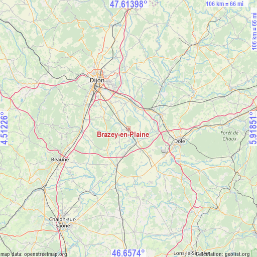
Brazey-en-Plaine GPS coordinates[2]
47° 8' 16.224" North, 5° 12' 55.368" East
| Map corner | latitude | longitude |
|---|---|---|
| Upper-left | 47.61398°, | 4.51226° |
| Center: | 47.13784°, | 5.21538° |
| Lower-right: | 46.6574°, | 5.91851° |
| Map W x H: | 106.4×106.4 km | = 66.1×66.1mi |
| max Lat: | 51.07786° ⇑53.8% North |
| Brazey-en-Plaine: | 47.13784° |
| min Lat: | ⇓46.2% South 41.3874° |
| min Long | Brazey-en-Plain | max Long |
| -5.08615° | 5.21538° | 9.52242° |
| W 79.9%⇐ | ⇒20.1% E |
Elevation
Elevation of Brazey-en-Plaine is 184 m = 604 ft, and this is 9.7 m = 32 ft below average elevation for this country.
| Max E: |
2333 m = 7654 ft | 37.1% |
| Avg. | 193.7 m = 635 ft | |
| Brazey-en-Plaine | 184 m = 604 ft | |
Min E: |
-1 m = -3 ft | 62.9% |
See also: France elevation on elevation.city.
Geographical zone
Brazey-en-Plaine is located in North temperate zone (between Tropic of Cancer and the Arctic Circle). Distance of this North polar circle is 2159.9 km =1342.1 mi to North.| Distance of | km | miles | from Brazey-en-Plaine |
|---|---|---|---|
| North Pole | 4765.8 | 2961.3 | to North |
| Arctic Circle | 2159.9 | 1342.1 | to North |
| Tropic Cancer | 2635.3 | 1637.5 | to South |
| Equator | 5241.2 | 3256.7 | to South |


Nearby cities:
15 places around Brazey-en-Plaine: (largest is in red/bold)
• Aiserey
5.5 km =3.4 mi,  313°
313°
• Champdôtre
8.3 km =5.2 mi,  53°
53°
• Esbarres
4.8 km =3 mi,  179°
179°
• Izeure
6.9 km =4.3 mi,  301°
301°
• Les Maillys
9.4 km =5.8 mi,  91°
91°
• Longeault
9.6 km =6 mi,  17°
17°
• Longecourt-en-Plaine
8.3 km =5.2 mi,  323°
323°
• Losne
5.6 km =3.5 mi,  141°
141°
• Pagny-le-Château
10.2 km =6.3 mi,  188°
188°
• Pluvault
8.8 km =5.5 mi, 19°
• Saint-Jean-de-Losne
5.5 km =3.4 mi, 136°
• Saint-Usage
4.6 km =2.9 mi,  132°
132°
• Tart-le-Haut
7.4 km =4.6 mi,  353°
353°
• Trouhans
4.6 km =2.9 mi,  75°
75°
• Échenon
5.7 km =3.5 mi,  114°
114°
Sources, notices
• [Note1] Compared only with cities in France existing in our database
• [Src1] Map data: © OpenStreetMap contributors (CC-BY-SA)
• [Src2] Other city data from geonames.org with taken over terms of usage.
• [Src3] Geographical zone / Annual Mean Temperature by Robert A. Rohde @ Wikipedia
