Saint-Usage geodata
Saint-Usage (Bourgogne-Franche-Comté) is a populated place; located in France in Europe/Paris (GMT+2) time zone. With population of 1,027 people, there are 8636 cities with bigger population in this country. Compared to other cities in France, 54.1% of cities are located further ↑North; 80.3% of cities are located further ←West and 62.9% of cities have lower elevation than Saint-Usage. Note1
Administrative division(s):
- Level 1: Bourgogne-Franche-Comté
- Level 2: Département de la Côte-d'Or
- Level 3: Arrondissement de Beaune
- Level 4: Saint-Usage


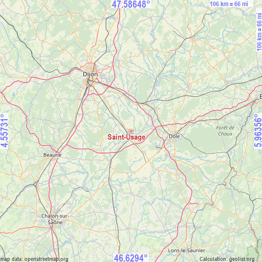
Saint-Usage GPS coordinates[2]
47° 6' 36.324" North, 5° 15' 37.584" East
| Map corner | latitude | longitude |
|---|---|---|
| Upper-left | 47.58648°, | 4.55731° |
| Center: | 47.11009°, | 5.26044° |
| Lower-right: | 46.6294°, | 5.96356° |
| Map W x H: | 106.4×106.4 km | = 66.1×66.1mi |
| max Lat: | 51.07786° ⇑54.1% North |
| Saint-Usage: | 47.11009° |
| min Lat: | ⇓45.9% South 41.3874° |
| min Long | Saint-Usage | max Long |
| -5.08615° | 5.26044° | 9.52242° |
| W 80.3%⇐ | ⇒19.7% E |
Elevation
Elevation of Saint-Usage is 184 m = 604 ft, and this is 9.7 m = 32 ft below average elevation for this country.
| Max E: |
2333 m = 7654 ft | 37.1% |
| Avg. | 193.7 m = 635 ft | |
| Saint-Usage | 184 m = 604 ft | |
Min E: |
-1 m = -3 ft | 62.9% |
See also: France elevation on elevation.city.
Geographical zone
Saint-Usage is located in North temperate zone (between Tropic of Cancer and the Arctic Circle). Distance of this North polar circle is 2163 km =1344 mi to North.| Distance of | km | miles | from Saint-Usage |
|---|---|---|---|
| North Pole | 4768.9 | 2963.3 | to North |
| Arctic Circle | 2163 | 1344 | to North |
| Tropic Cancer | 2632.2 | 1635.6 | to South |
| Equator | 5238.2 | 3254.9 | to South |


Nearby cities:
15 places around Saint-Usage: (largest is in red/bold)
• Abergement-la-Ronce
9.6 km =6 mi,  118°
118°
• Aiserey
10.1 km =6.3 mi,  313°
313°
• Brazey-en-Plaine
4.6 km =2.9 mi, 312°
• Champdôtre
8.6 km =5.3 mi,  22°
22°
• Esbarres
3.8 km =2.4 mi,  243°
243°
• Izeure
11.4 km =7.1 mi, 305°
• Les Maillys
6.6 km =4.1 mi,  64°
64°
• Losne
1.3 km =0.8 mi,  174°
174°
• Pagny-le-Château
8.6 km =5.3 mi,  215°
215°
• Saint-Aubin
9.9 km =6.2 mi,  149°
149°
• Saint-Jean-de-Losne
0.9 km =0.6 mi,  155°
155°
• Tart-le-Haut
11.2 km =7 mi,  338°
338°
• Tillenay
10.2 km =6.3 mi,  41°
41°
• Trouhans
4.4 km =2.7 mi,  14°
14°
• Échenon
1.9 km =1.2 mi,  67°
67°
Sources, notices
• [Note1] Compared only with cities in France existing in our database
• [Src1] Map data: © OpenStreetMap contributors (CC-BY-SA)
• [Src2] Other city data from geonames.org with taken over terms of usage.
• [Src3] Geographical zone / Annual Mean Temperature by Robert A. Rohde @ Wikipedia
