Saint-Amand-Longpré geodata
Saint-Amand-Longpré (Centre) is a populated place; located in France in Europe/Paris (GMT+2) time zone. With population of 1,083 people, there are 8242 cities with bigger population in this country. Compared to other cities in France, 54% of cities are located further ↓South; 68.6% of cities are located further →East and 53.8% of cities have higher elevation than Saint-Amand-Longpré. Note1
Administrative division(s):
- Level 1: Centre
- Level 2: Département du Loir-et-Cher
- Level 3: Arrondissement de Vendôme
- Level 4: Saint-Amand-Longpré


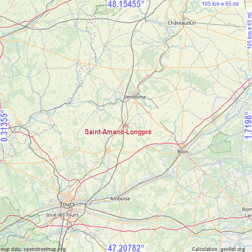
Saint-Amand-Longpré GPS coordinates[2]
47° 40' 59.988" North, 1° 1' 0.012" East
| Map corner | latitude | longitude |
|---|---|---|
| Upper-left | 48.15455°, | 0.31355° |
| Center: | 47.68333°, | 1.01667° |
| Lower-right: | 47.20782°, | 1.7198° |
| Map W x H: | 105.3×105.3 km | = 65.4×65.4mi |
| max Lat: | 51.07786° ⇑46% North |
| Saint-Amand-Longpré: | 47.68333° |
| min Lat: | ⇓54% South 41.3874° |
| min Long | Saint-Amand-Lon | max Long |
| -5.08615° | 1.01667° | 9.52242° |
| W 31.4%⇐ | ⇒68.6% E |
Elevation
Elevation of Saint-Amand-Longpré is 120 m = 394 ft, and this is 73.7 m = 242 ft below average elevation for this country.
| Max E: |
2333 m = 7654 ft | 53.8% |
| Avg. | 193.7 m = 635 ft | |
| Saint-Amand-Longpré | 120 m = 394 ft | |
Min E: |
-1 m = -3 ft | 46.2% |
See also: France elevation on elevation.city.
Geographical zone
Saint-Amand-Longpré is located in North temperate zone (between Tropic of Cancer and the Arctic Circle). Distance of this North polar circle is 2099.3 km =1304.4 mi to North.| Distance of | km | miles | from Saint-Amand-Longpré |
|---|---|---|---|
| North Pole | 4705.2 | 2923.7 | to North |
| Arctic Circle | 2099.3 | 1304.4 | to North |
| Tropic Cancer | 2696 | 1675.2 | to South |
| Equator | 5301.9 | 3294.4 | to South |


Nearby cities:
15 places around Saint-Amand-Longpré: (largest is in red/bold)
• Areines
14.5 km =9 mi,  23°
23°
• Authon
10 km =6.2 mi,  244°
244°
• Château-Renault
12.9 km =8 mi,  217°
217°
• Herbault
12.7 km =7.9 mi,  133°
133°
• Landes-le-Gaulois
13 km =8.1 mi,  104°
104°
• Monthodon
14 km =8.7 mi,  254°
254°
• Montoire-sur-le-Loir
13.7 km =8.5 mi,  304°
304°
• Naveil
12.6 km =7.8 mi,  5°
5°
• Neuville-sur-Brenne
10.5 km =6.5 mi,  225°
225°
• Prunay-Cassereau
7.4 km =4.6 mi,  280°
280°
• Saunay
9.5 km =5.9 mi,  201°
201°
• Thoré-la-Rochette
12.2 km =7.6 mi,  341°
341°
• Vendôme
12.7 km =7.9 mi, 16°
• Villerable
8.3 km =5.2 mi, 7°
• Villiers-sur-Loir
13.6 km =8.5 mi,  354°
354°
Sources, notices
• [Note1] Compared only with cities in France existing in our database
• [Src1] Map data: © OpenStreetMap contributors (CC-BY-SA)
• [Src2] Other city data from geonames.org with taken over terms of usage.
• [Src3] Geographical zone / Annual Mean Temperature by Robert A. Rohde @ Wikipedia
