Sargé-sur-Braye geodata
Sargé-sur-Braye (Centre) is a populated place; located in France in Europe/Paris (GMT+2) time zone. With population of 1,012 people, there are 8758 cities with bigger population in this country. Compared to other cities in France, 58% of cities are located further ↓South; 70.1% of cities are located further →East and 61.5% of cities have higher elevation than Sargé-sur-Braye. Note1
Administrative division(s):
- Level 1: Centre
- Level 2: Département du Loir-et-Cher
- Level 3: Arrondissement de Vendôme
- Level 4: Sargé-sur-Braye


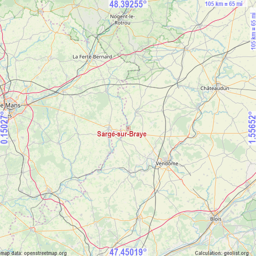
Sargé-sur-Braye GPS coordinates[2]
47° 55' 24.672" North, 0° 51' 12.24" East
| Map corner | latitude | longitude |
|---|---|---|
| Upper-left | 48.39255°, | 0.15027° |
| Center: | 47.92352°, | 0.8534° |
| Lower-right: | 47.45019°, | 1.55652° |
| Map W x H: | 104.8×104.8 km | = 65.1×65.1mi |
| max Lat: | 51.07786° ⇑42% North |
| Sargé-sur-Braye: | 47.92352° |
| min Lat: | ⇓58% South 41.3874° |
| min Long | Sargé-sur-Bray | max Long |
| -5.08615° | 0.8534° | 9.52242° |
| W 29.9%⇐ | ⇒70.1% E |
Elevation
Elevation of Sargé-sur-Braye is 98 m = 322 ft, and this is 95.7 m = 314 ft below average elevation for this country.
| Max E: |
2333 m = 7654 ft | 61.5% |
| Avg. | 193.7 m = 635 ft | |
| Sargé-sur-Braye | 98 m = 322 ft | |
Min E: |
-1 m = -3 ft | 38.5% |
See also: France elevation on elevation.city.
Geographical zone
Sargé-sur-Braye is located in North temperate zone (between Tropic of Cancer and the Arctic Circle). Distance of this North polar circle is 2072.6 km =1287.9 mi to North.| Distance of | km | miles | from Sargé-sur-Braye |
|---|---|---|---|
| North Pole | 4678.5 | 2907.1 | to North |
| Arctic Circle | 2072.6 | 1287.9 | to North |
| Tropic Cancer | 2722.7 | 1691.8 | to South |
| Equator | 5328.6 | 3311 | to South |


Nearby cities:
15 places around Sargé-sur-Braye: (largest is in red/bold)
• Azé
13.5 km =8.4 mi,  126°
126°
• Bessé-sur-Braye
12.7 km =7.9 mi,  217°
217°
• Choue
10.4 km =6.5 mi,  34°
34°
• Conflans-sur-Anille
8.4 km =5.2 mi,  286°
286°
• Cormenon
5.8 km =3.6 mi, 30°
• Danzé
13.2 km =8.2 mi,  104°
104°
• La Chapelle-Huon
11 km =6.8 mi,  227°
227°
• Lunay
13.6 km =8.5 mi,  160°
160°
• Mazangé
13 km =8.1 mi,  148°
148°
• Mondoubleau
7.2 km =4.5 mi, 27°
• Montaillé
11.3 km =7 mi,  277°
277°
• Saint-Calais
8 km =5 mi,  268°
268°
• Savigny-sur-Braye
5.9 km =3.7 mi,  213°
213°
• Souday
12.6 km =7.8 mi,  4°
4°
• Épuisay
6.3 km =3.9 mi,  113°
113°
Sources, notices
• [Note1] Compared only with cities in France existing in our database
• [Src1] Map data: © OpenStreetMap contributors (CC-BY-SA)
• [Src2] Other city data from geonames.org with taken over terms of usage.
• [Src3] Geographical zone / Annual Mean Temperature by Robert A. Rohde @ Wikipedia
