Mazangé geodata
Mazangé (Centre) is a populated place; located in France in Europe/Paris (GMT+2) time zone. With population of 866 people, there are 9930 cities with bigger population in this country. Compared to other cities in France, 56.2% of cities are located further ↓South; 69.3% of cities are located further →East and 67.4% of cities have higher elevation than Mazangé. Note1
Administrative division(s):
- Level 1: Centre
- Level 2: Département du Loir-et-Cher
- Level 3: Arrondissement de Vendôme
- Level 4: Mazangé


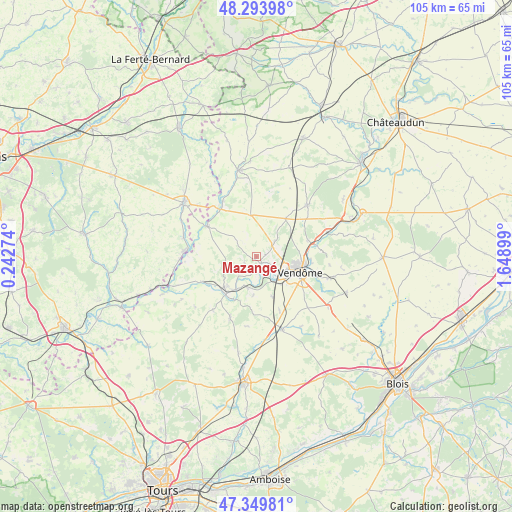
Mazangé GPS coordinates[2]
47° 49' 26.544" North, 0° 56' 45.096" East
| Map corner | latitude | longitude |
|---|---|---|
| Upper-left | 48.29398°, | 0.24274° |
| Center: | 47.82404°, | 0.94586° |
| Lower-right: | 47.34981°, | 1.64899° |
| Map W x H: | 105×105 km | = 65.2×65.2mi |
| max Lat: | 51.07786° ⇑43.8% North |
| Mazangé: | 47.82404° |
| min Lat: | ⇓56.2% South 41.3874° |
| min Long | Mazangé | max Long |
| -5.08615° | 0.94586° | 9.52242° |
| W 30.7%⇐ | ⇒69.3% E |
Elevation
Elevation of Mazangé is 84 m = 276 ft, and this is 109.7 m = 360 ft below average elevation for this country.
| Max E: |
2333 m = 7654 ft | 67.4% |
| Avg. | 193.7 m = 635 ft | |
| Mazangé | 84 m = 276 ft | |
Min E: |
-1 m = -3 ft | 32.6% |
See also: France elevation on elevation.city.
Geographical zone
Mazangé is located in North temperate zone (between Tropic of Cancer and the Arctic Circle). Distance of this North polar circle is 2083.6 km =1294.7 mi to North.| Distance of | km | miles | from Mazangé |
|---|---|---|---|
| North Pole | 4689.5 | 2913.9 | to North |
| Arctic Circle | 2083.6 | 1294.7 | to North |
| Tropic Cancer | 2711.6 | 1684.9 | to South |
| Equator | 5317.5 | 3304.1 | to South |


Nearby cities:
15 places around Mazangé: (largest is in red/bold)
• Areines
11.4 km =7.1 mi,  101°
101°
• Azé
5 km =3.1 mi,  52°
52°
• Danzé
9.8 km =6.1 mi,  37°
37°
• Lunay
2.9 km =1.8 mi,  233°
233°
• Montoire-sur-le-Loir
9.9 km =6.2 mi,  217°
217°
• Naveil
7.2 km =4.5 mi,  115°
115°
• Saint-Firmin-des-Prés
12.7 km =7.9 mi,  81°
81°
• Saint-Ouen
10.1 km =6.3 mi, 96°
• Sargé-sur-Braye
13 km =8.1 mi,  328°
328°
• Savigny-sur-Braye
11.9 km =7.4 mi,  301°
301°
• Thoré-la-Rochette
4.3 km =2.7 mi,  162°
162°
• Vendôme
9.6 km =6 mi,  111°
111°
• Villerable
9.8 km =6.1 mi,  139°
139°
• Villiers-sur-Loir
4.4 km =2.7 mi, 118°
• Épuisay
8.6 km =5.3 mi,  352°
352°
Sources, notices
• [Note1] Compared only with cities in France existing in our database
• [Src1] Map data: © OpenStreetMap contributors (CC-BY-SA)
• [Src2] Other city data from geonames.org with taken over terms of usage.
• [Src3] Geographical zone / Annual Mean Temperature by Robert A. Rohde @ Wikipedia
