Cormenon geodata
Cormenon (Centre) is a populated place; located in France in Europe/Paris (GMT+2) time zone. With population of 724 people, there are 11480 cities with bigger population in this country. Compared to other cities in France, 58.7% of cities are located further ↓South; 69.8% of cities are located further →East and 57.3% of cities have higher elevation than Cormenon. Note1
Administrative division(s):
- Level 1: Centre
- Level 2: Département du Loir-et-Cher
- Level 3: Arrondissement de Vendôme
- Level 4: Cormenon


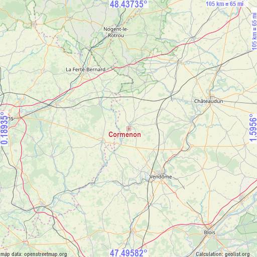
Cormenon GPS coordinates[2]
47° 58' 7.428" North, 0° 53' 32.892" East
| Map corner | latitude | longitude |
|---|---|---|
| Upper-left | 48.43735°, | 0.18935° |
| Center: | 47.96873°, | 0.89247° |
| Lower-right: | 47.49582°, | 1.5956° |
| Map W x H: | 104.7×104.7 km | = 65.1×65.1mi |
| max Lat: | 51.07786° ⇑41.3% North |
| Cormenon: | 47.96873° |
| min Lat: | ⇓58.7% South 41.3874° |
| min Long | Cormenon | max Long |
| -5.08615° | 0.89247° | 9.52242° |
| W 30.2%⇐ | ⇒69.8% E |
Elevation
Elevation of Cormenon is 110 m = 361 ft, and this is 83.7 m = 275 ft below average elevation for this country.
| Max E: |
2333 m = 7654 ft | 57.3% |
| Avg. | 193.7 m = 635 ft | |
| Cormenon | 110 m = 361 ft | |
Min E: |
-1 m = -3 ft | 42.7% |
See also: France elevation on elevation.city.
Geographical zone
Cormenon is located in North temperate zone (between Tropic of Cancer and the Arctic Circle). Distance of this North polar circle is 2067.6 km =1284.7 mi to North.| Distance of | km | miles | from Cormenon |
|---|---|---|---|
| North Pole | 4673.4 | 2903.9 | to North |
| Arctic Circle | 2067.6 | 1284.7 | to North |
| Tropic Cancer | 2727.7 | 1694.9 | to South |
| Equator | 5333.6 | 3314.1 | to South |


Nearby cities:
15 places around Cormenon: (largest is in red/bold)
• Azé
15.2 km =9.4 mi,  148°
148°
• Choue
4.6 km =2.9 mi,  41°
41°
• Conflans-sur-Anille
11.3 km =7 mi,  256°
256°
• Danzé
12.9 km =8 mi,  129°
129°
• Droué
15.8 km =9.8 mi,  59°
59°
• La Ville-aux-Clercs
15.4 km =9.6 mi,  111°
111°
• Melleray
16 km =9.9 mi,  334°
334°
• Mondoubleau
1.4 km =0.9 mi,  16°
16°
• Montaillé
14.6 km =9.1 mi, 255°
• Saint-Calais
12.1 km =7.5 mi,  244°
244°
• Sargé-sur-Braye
5.8 km =3.6 mi,  210°
210°
• Savigny-sur-Braye
11.7 km =7.3 mi, 211°
• Souday
7.8 km =4.8 mi,  345°
345°
• Vibraye
14.8 km =9.2 mi,  310°
310°
• Épuisay
8.1 km =5 mi,  159°
159°
Sources, notices
• [Note1] Compared only with cities in France existing in our database
• [Src1] Map data: © OpenStreetMap contributors (CC-BY-SA)
• [Src2] Other city data from geonames.org with taken over terms of usage.
• [Src3] Geographical zone / Annual Mean Temperature by Robert A. Rohde @ Wikipedia
