Sannois geodata
Sannois (Île-de-France) is a populated place; located in France in Europe/Paris (GMT+2) time zone. With population of 26,869 people, there are 317 cities with bigger population in this country. Compared to other cities in France, 78.9% of cities are located further ↓South; 53.5% of cities are located further →East and 58.3% of cities have higher elevation than Sannois. Note1
Administrative division(s):
- Level 1: Île-de-France
- Level 2: Département du Val-d’Oise
- Level 3: Arrondissement d'Argenteuil
- Level 4: Sannois


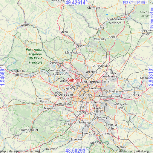
Sannois GPS coordinates[2]
48° 58' 0.012" North, 2° 15' 0" East
| Map corner | latitude | longitude |
|---|---|---|
| Upper-left | 49.42614°, | 1.54688° |
| Center: | 48.96667°, | 2.25° |
| Lower-right: | 48.50293°, | 2.95313° |
| Map W x H: | 102.7×102.6 km | = 63.8×63.8mi |
| max Lat: | 51.07786° ⇑21.1% North |
| Sannois: | 48.96667° |
| min Lat: | ⇓78.9% South 41.3874° |
| min Long | Sannois | max Long |
| -5.08615° | 2.25° | 9.52242° |
| W 46.5%⇐ | ⇒53.5% E |
Elevation
Elevation of Sannois is 107 m = 351 ft, and this is 86.7 m = 284 ft below average elevation for this country.
| Max E: |
2333 m = 7654 ft | 58.3% |
| Avg. | 193.7 m = 635 ft | |
| Sannois | 107 m = 351 ft | |
Min E: |
-1 m = -3 ft | 41.7% |
See also: France elevation on elevation.city.
Geographical zone
Sannois is located in North temperate zone (between Tropic of Cancer and the Arctic Circle). Distance of this North polar circle is 1956.6 km =1215.8 mi to North.| Distance of | km | miles | from Sannois |
|---|---|---|---|
| North Pole | 4562.5 | 2835 | to North |
| Arctic Circle | 1956.6 | 1215.8 | to North |
| Tropic Cancer | 2838.7 | 1763.9 | to South |
| Equator | 5444.6 | 3383.1 | to South |


Nearby cities:
15 places around Sannois: (largest is in red/bold)
• Argenteuil
2.1 km =1.3 mi,  185°
185°
• Cormeilles-en-Parisis
3.3 km =2.1 mi,  278°
278°
• Eaubonne
4.1 km =2.5 mi,  35°
35°
• Enghien-les-Bains
4.9 km =3 mi,  90°
90°
• Ermont
2.7 km =1.7 mi,  12°
12°
• Franconville
2.2 km =1.4 mi,  326°
326°
• Gennevilliers
5.2 km =3.2 mi,  135°
135°
• Le Plessis-Bouchard
3.9 km =2.4 mi,  341°
341°
• Margency
5.2 km =3.2 mi, 44°
• Montigny-lès-Cormeilles
4 km =2.5 mi,  295°
295°
• Montlignon
5.2 km =3.2 mi,  31°
31°
• Saint-Gratien
2.8 km =1.7 mi,  74°
74°
• Sartrouville
4.7 km =2.9 mi,  244°
244°
• Soisy-sous-Montmorency
4.5 km =2.8 mi,  57°
57°
• Épinay-sur-Seine
5 km =3.1 mi,  107°
107°
Sources, notices
• [Note1] Compared only with cities in France existing in our database
• [Src1] Map data: © OpenStreetMap contributors (CC-BY-SA)
• [Src2] Other city data from geonames.org with taken over terms of usage.
• [Src3] Geographical zone / Annual Mean Temperature by Robert A. Rohde @ Wikipedia
