Salbris geodata
Salbris (Centre) is a populated place; located in France in Europe/Paris (GMT+2) time zone. With population of 5,810 people, there are 1698 cities with bigger population in this country. Compared to other cities in France, 50.2% of cities are located further ↓South; 56.4% of cities are located further →East and 57.9% of cities have higher elevation than Salbris. Note1
Administrative division(s):
- Level 1: Centre
- Level 2: Département du Loir-et-Cher
- Level 3: Arrondissement de Romorantin-Lanthenay
- Level 4: Salbris


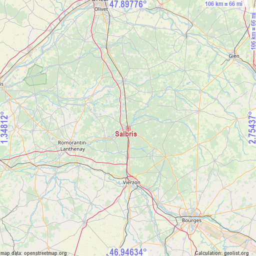
Salbris GPS coordinates[2]
47° 25' 27.12" North, 2° 3' 4.464" East
| Map corner | latitude | longitude |
|---|---|---|
| Upper-left | 47.89776°, | 1.34812° |
| Center: | 47.4242°, | 2.05124° |
| Lower-right: | 46.94634°, | 2.75437° |
| Map W x H: | 105.8×105.8 km | = 65.7×65.7mi |
| max Lat: | 51.07786° ⇑49.8% North |
| Salbris: | 47.4242° |
| min Lat: | ⇓50.2% South 41.3874° |
| min Long | Salbris | max Long |
| -5.08615° | 2.05124° | 9.52242° |
| W 43.6%⇐ | ⇒56.4% E |
Elevation
Elevation of Salbris is 108 m = 354 ft, and this is 85.7 m = 281 ft below average elevation for this country.
| Max E: |
2333 m = 7654 ft | 57.9% |
| Avg. | 193.7 m = 635 ft | |
| Salbris | 108 m = 354 ft | |
Min E: |
-1 m = -3 ft | 42.1% |
See also: France elevation on elevation.city.
Geographical zone
Salbris is located in North temperate zone (between Tropic of Cancer and the Arctic Circle). Distance of this North polar circle is 2128.1 km =1322.3 mi to North.| Distance of | km | miles | from Salbris |
|---|---|---|---|
| North Pole | 4734 | 2941.6 | to North |
| Arctic Circle | 2128.1 | 1322.3 | to North |
| Tropic Cancer | 2667.2 | 1657.3 | to South |
| Equator | 5273.1 | 3276.6 | to South |


Nearby cities:
15 places around Salbris: (largest is in red/bold)
• La Ferté-Beauharnais
20 km =12.4 mi,  310°
310°
• La Ferté-Imbault
8.6 km =5.3 mi,  239°
239°
• Lamotte-Beuvron
19.8 km =12.3 mi,  355°
355°
• Marcilly-en-Gault
14.1 km =8.8 mi,  289°
289°
• Méry-sur-Cher
20.3 km =12.6 mi,  193°
193°
• Nançay
13.5 km =8.4 mi,  127°
127°
• Neuvy-sur-Barangeon
19.5 km =12.1 mi, 128°
• Nouan-le-Fuzelier
12.5 km =7.8 mi,  354°
354°
• Pierrefitte-sur-Sauldre
12.3 km =7.6 mi,  37°
37°
• Saint-Viâtre
14.3 km =8.9 mi,  321°
321°
• Selles-Saint-Denis
10.5 km =6.5 mi,  246°
246°
• Souesmes
10 km =6.2 mi,  68°
68°
• Theillay
12.2 km =7.6 mi,  183°
183°
• Thénioux
20.6 km =12.8 mi,  204°
204°
• Villeherviers
20 km =12.4 mi, 251°
Sources, notices
• [Note1] Compared only with cities in France existing in our database
• [Src1] Map data: © OpenStreetMap contributors (CC-BY-SA)
• [Src2] Other city data from geonames.org with taken over terms of usage.
• [Src3] Geographical zone / Annual Mean Temperature by Robert A. Rohde @ Wikipedia
