La Ferté-Beauharnais geodata
La Ferté-Beauharnais (Centre) is a populated place; located in France in Europe/Paris (GMT+2) time zone. With population of 520 people, there are 14814 cities with bigger population in this country. Compared to other cities in France, 51.9% of cities are located further ↓South; 58.8% of cities are located further →East and 60% of cities have higher elevation than La Ferté-Beauharnais. Note1
Administrative division(s):
- Level 1: Centre
- Level 2: Département du Loir-et-Cher
- Level 3: Arrondissement de Romorantin-Lanthenay
- Level 4: La Ferté-Beauharnais


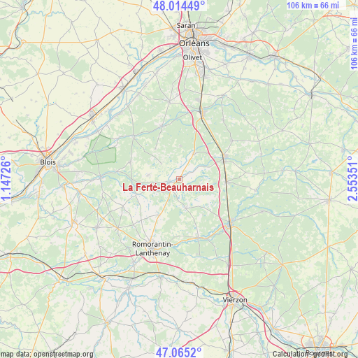
La Ferté-Beauharnais GPS coordinates[2]
47° 32' 31.164" North, 1° 51' 1.368" East
| Map corner | latitude | longitude |
|---|---|---|
| Upper-left | 48.01449°, | 1.14726° |
| Center: | 47.54199°, | 1.85038° |
| Lower-right: | 47.0652°, | 2.55351° |
| Map W x H: | 105.6×105.5 km | = 65.6×65.6mi |
| max Lat: | 51.07786° ⇑48.1% North |
| La Ferté-Beauharnais: | 47.54199° |
| min Lat: | ⇓51.9% South 41.3874° |
| min Long | La Ferté-Beauh | max Long |
| -5.08615° | 1.85038° | 9.52242° |
| W 41.2%⇐ | ⇒58.8% E |
Elevation
Elevation of La Ferté-Beauharnais is 102 m = 335 ft, and this is 91.7 m = 301 ft below average elevation for this country.
| Max E: |
2333 m = 7654 ft | 60% |
| Avg. | 193.7 m = 635 ft | |
| La Ferté-Beauharnais | 102 m = 335 ft | |
Min E: |
-1 m = -3 ft | 40% |
See also: France elevation on elevation.city.
Geographical zone
La Ferté-Beauharnais is located in North temperate zone (between Tropic of Cancer and the Arctic Circle). Distance of this North polar circle is 2115 km =1314.2 mi to North.| Distance of | km | miles | from La Ferté-Beauharnais |
|---|---|---|---|
| North Pole | 4720.9 | 2933.4 | to North |
| Arctic Circle | 2115 | 1314.2 | to North |
| Tropic Cancer | 2680.3 | 1665.5 | to South |
| Equator | 5286.2 | 3284.7 | to South |


Nearby cities:
15 places around La Ferté-Beauharnais: (largest is in red/bold)
• Chaumont-sur-Tharonne
8.6 km =5.3 mi,  28°
28°
• Dhuizon
15.3 km =9.5 mi,  289°
289°
• La Ferté-Imbault
19.1 km =11.9 mi,  156°
156°
• La Ferté-Saint-Cyr
18.4 km =11.4 mi,  313°
313°
• Lamotte-Beuvron
14.9 km =9.3 mi,  63°
63°
• Ligny-le-Ribault
16.6 km =10.3 mi,  341°
341°
• Marcilly-en-Gault
8.7 km =5.4 mi,  167°
167°
• Millançay
12.1 km =7.5 mi,  209°
209°
• Montrieux-en-Sologne
9.4 km =5.8 mi,  278°
278°
• Neung-sur-Beuvron
3.5 km =2.2 mi,  256°
256°
• Nouan-le-Fuzelier
14 km =8.7 mi,  92°
92°
• Saint-Viâtre
6.5 km =4 mi,  107°
107°
• Selles-Saint-Denis
18.1 km =11.2 mi, 162°
• Vernou-en-Sologne
13.5 km =8.4 mi,  250°
250°
• Yvoy-le-Marron
10 km =6.2 mi,  1°
1°
Sources, notices
• [Note1] Compared only with cities in France existing in our database
• [Src1] Map data: © OpenStreetMap contributors (CC-BY-SA)
• [Src2] Other city data from geonames.org with taken over terms of usage.
• [Src3] Geographical zone / Annual Mean Temperature by Robert A. Rohde @ Wikipedia
