Saint-Maurice geodata
Saint-Maurice (Nouvelle-Aquitaine) is a populated place; located in France in Europe/Paris (GMT+2) time zone. With population of 540 people, there are 14387 cities with bigger population in this country. Compared to other cities in France, 54.9% of cities are located further ↑North; 83.5% of cities are located further →East and 51.4% of cities have higher elevation than Saint-Maurice. Note1
Administrative division(s):
- Level 1: Nouvelle-Aquitaine
- Level 2: Département des Deux-Sèvres
- Level 3: Arrondissement de Bressuire
- Level 4: Saint Maurice Étusson


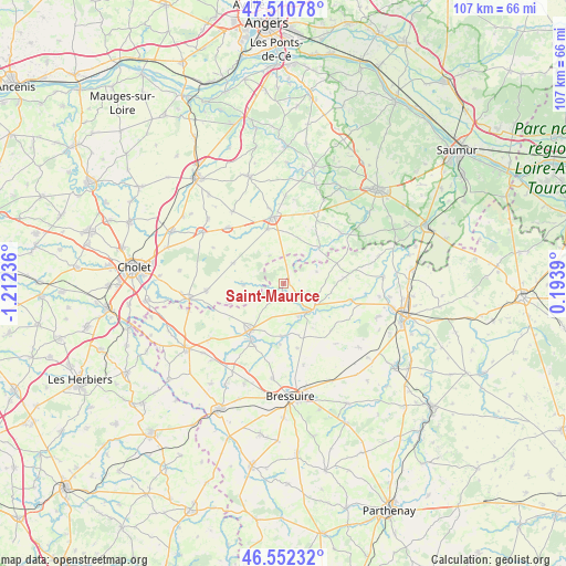
Saint-Maurice GPS coordinates[2]
47° 2' 1.32" North, 0° 30' 33.228" West
| Map corner | latitude | longitude |
|---|---|---|
| Upper-left | 47.51078°, | -1.21236° |
| Center: | 47.0337°, | -0.50923° |
| Lower-right: | 46.55232°, | 0.1939° |
| Map W x H: | 106.6×106.6 km | = 66.2×66.2mi |
| max Lat: | 51.07786° ⇑54.9% North |
| Saint-Maurice: | 47.0337° |
| min Lat: | ⇓45.1% South 41.3874° |
| min Long | Saint-Maurice | max Long |
| -5.08615° | -0.50923° | 9.52242° |
| W 16.5%⇐ | ⇒83.5% E |
Elevation
Elevation of Saint-Maurice is 127 m = 417 ft, and this is 66.7 m = 219 ft below average elevation for this country.
| Max E: |
2333 m = 7654 ft | 51.4% |
| Avg. | 193.7 m = 635 ft | |
| Saint-Maurice | 127 m = 417 ft | |
Min E: |
-1 m = -3 ft | 48.6% |
See also: France elevation on elevation.city.
Geographical zone
Saint-Maurice is located in North temperate zone (between Tropic of Cancer and the Arctic Circle). Distance of this North polar circle is 2171.5 km =1349.3 mi to North.| Distance of | km | miles | from Saint-Maurice |
|---|---|---|---|
| North Pole | 4777.4 | 2968.5 | to North |
| Arctic Circle | 2171.5 | 1349.3 | to North |
| Tropic Cancer | 2623.7 | 1630.3 | to South |
| Equator | 5229.7 | 3249.6 | to South |


Nearby cities:
15 places around Saint-Maurice: (largest is in red/bold)
• Argenton-les-Vallées
7 km =4.3 mi,  140°
140°
• Boësse
6.9 km =4.3 mi,  156°
156°
• Cersay
11.8 km =7.3 mi,  83°
83°
• Coron
14.6 km =9.1 mi,  315°
315°
• La Plaine
10.3 km =6.4 mi,  291°
291°
• Massais
12.9 km =8 mi,  104°
104°
• Moutiers-sous-Argenton
12.5 km =7.8 mi,  134°
134°
• Nueil-les-Aubiers
12.5 km =7.8 mi,  206°
206°
• Nueil-sur-Layon
14.4 km =8.9 mi,  49°
49°
• Saint-Aubin-du-Plain
12.5 km =7.8 mi,  168°
168°
• Saint-Paul-du-Bois
5.8 km =3.6 mi,  332°
332°
• Somloire
7.5 km =4.7 mi,  268°
268°
• Vihiers
12.6 km =7.8 mi,  352°
352°
• Voulmentin
10 km =6.2 mi,  182°
182°
• Yzernay
14.7 km =9.1 mi, 265°
Sources, notices
• [Note1] Compared only with cities in France existing in our database
• [Src1] Map data: © OpenStreetMap contributors (CC-BY-SA)
• [Src2] Other city data from geonames.org with taken over terms of usage.
• [Src3] Geographical zone / Annual Mean Temperature by Robert A. Rohde @ Wikipedia
