Boësse geodata
Boësse (Nouvelle-Aquitaine) is a populated place; located in France in Europe/Paris (GMT+2) time zone. With population of 549 people, there are 14229 cities with bigger population in this country. Compared to other cities in France, 55.5% of cities are located further ↑North; 83% of cities are located further →East and 53.3% of cities have higher elevation than Boësse. Note1
Administrative division(s):
- Level 1: Nouvelle-Aquitaine
- Level 2: Département des Deux-Sèvres
- Level 3: Arrondissement de Bressuire
- Level 4: Argentonnay


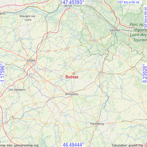
Boësse GPS coordinates[2]
46° 58' 34.824" North, 0° 28' 22.224" West
| Map corner | latitude | longitude |
|---|---|---|
| Upper-left | 47.45393°, | -1.17596° |
| Center: | 46.97634°, | -0.47284° |
| Lower-right: | 46.49444°, | 0.23028° |
| Map W x H: | 106.7×106.7 km | = 66.3×66.3mi |
| max Lat: | 51.07786° ⇑55.5% North |
| Boësse: | 46.97634° |
| min Lat: | ⇓44.5% South 41.3874° |
| min Long | Boësse | max Long |
| -5.08615° | -0.47284° | 9.52242° |
| W 17%⇐ | ⇒83% E |
Elevation
Elevation of Boësse is 121 m = 397 ft, and this is 72.7 m = 239 ft below average elevation for this country.
| Max E: |
2333 m = 7654 ft | 53.3% |
| Avg. | 193.7 m = 635 ft | |
| Boësse | 121 m = 397 ft | |
Min E: |
-1 m = -3 ft | 46.7% |
See also: France elevation on elevation.city.
Geographical zone
Boësse is located in North temperate zone (between Tropic of Cancer and the Arctic Circle). Distance of this North polar circle is 2177.9 km =1353.3 mi to North.| Distance of | km | miles | from Boësse |
|---|---|---|---|
| North Pole | 4783.8 | 2972.5 | to North |
| Arctic Circle | 2177.9 | 1353.3 | to North |
| Tropic Cancer | 2617.4 | 1626.4 | to South |
| Equator | 5223.3 | 3245.6 | to South |


Nearby cities:
15 places around Boësse: (largest is in red/bold)
• Argenton-les-Vallées
2 km =1.2 mi,  60°
60°
• Bressuire
15 km =9.3 mi,  185°
185°
• Bretignolles
16.2 km =10.1 mi,  218°
218°
• Cersay
11.9 km =7.4 mi,  49°
49°
• La Plaine
16 km =9.9 mi,  309°
309°
• Massais
10.3 km =6.4 mi,  71°
71°
• Mauzé-Thouarsais
14.7 km =9.1 mi,  90°
90°
• Moutiers-sous-Argenton
6.6 km =4.1 mi,  111°
111°
• Nueil-les-Aubiers
9.7 km =6 mi,  240°
240°
• Saint-Aubin-du-Plain
5.8 km =3.6 mi,  182°
182°
• Saint-Maurice
6.9 km =4.3 mi,  336°
336°
• Saint-Paul-du-Bois
12.7 km =7.9 mi,  334°
334°
• Sainte-Radegonde
16.9 km =10.5 mi, 87°
• Somloire
12 km =7.5 mi,  301°
301°
• Voulmentin
4.8 km =3 mi, 221°
Sources, notices
• [Note1] Compared only with cities in France existing in our database
• [Src1] Map data: © OpenStreetMap contributors (CC-BY-SA)
• [Src2] Other city data from geonames.org with taken over terms of usage.
• [Src3] Geographical zone / Annual Mean Temperature by Robert A. Rohde @ Wikipedia
