Saint-Martin-de-Bonfossé geodata
Saint-Martin-de-Bonfossé (Normandy) is a populated place; located in France in Europe/Paris (GMT+2) time zone. With population of 525 people, there are 14719 cities with bigger population in this country. Compared to other cities in France, 81% of cities are located further ↓South; 89.8% of cities are located further →East and 59.7% of cities have higher elevation than Saint-Martin-de-Bonfossé. Note1
Administrative division(s):
- Level 1: Normandy
- Level 2: Manche
- Level 3: Arrondissement de Saint-Lô
- Level 4: Saint-Martin-de-Bonfossé
Current local time in Saint-Martin-de-Bonfossé:
04:49 PM, SaturdayDifference from your time zone: hours


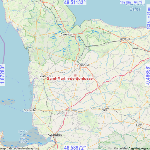
Saint-Martin-de-Bonfossé GPS coordinates[2]
49° 3' 9.576" North, 1° 10' 10.92" West
| Map corner | latitude | longitude |
|---|---|---|
| Upper-left | 49.51133°, | -1.87283° |
| Center: | 49.05266°, | -1.1697° |
| Lower-right: | 48.58972°, | -0.46658° |
| Map W x H: | 102.5×102.5 km | = 63.7×63.7mi |
| max Lat: | 51.07786° ⇑19% North |
| Saint-Martin-de-Bonfossé: | 49.05266° |
| min Lat: | ⇓81% South 41.3874° |
| min Long | Saint-Martin-de | max Long |
| -5.08615° | -1.1697° | 9.52242° |
| W 10.2%⇐ | ⇒89.8% E |
Elevation
Elevation of Saint-Martin-de-Bonfossé is 103 m = 338 ft, and this is 90.7 m = 298 ft below average elevation for this country.
| Max E: |
2333 m = 7654 ft | 59.7% |
| Avg. | 193.7 m = 635 ft | |
| Saint-Martin-de-Bonfossé | 103 m = 338 ft | |
Min E: |
-1 m = -3 ft | 40.3% |
See also: France elevation on elevation.city.
Geographical zone
Saint-Martin-de-Bonfossé is located in North temperate zone (between Tropic of Cancer and the Arctic Circle). Distance of this North polar circle is 1947 km =1209.8 mi to North.| Distance of | km | miles | from Saint-Martin-de-Bonfossé |
|---|---|---|---|
| North Pole | 4552.9 | 2829 | to North |
| Arctic Circle | 1947 | 1209.8 | to North |
| Tropic Cancer | 2848.2 | 1769.8 | to South |
| Equator | 5454.1 | 3389 | to South |


Nearby cities:
15 places around Saint-Martin-de-Bonfossé: (largest is in red/bold)
• Agneaux
8.7 km =5.4 mi,  32°
32°
• Canisy
2.6 km =1.6 mi,  349°
349°
• Carantilly
5.4 km =3.4 mi,  285°
285°
• Cerisy-la-Salle
8.8 km =5.5 mi,  250°
250°
• Dangy
4.1 km =2.5 mi,  257°
257°
• Hébécrevon
8.3 km =5.2 mi,  1°
1°
• La Mancellière-sur-Vire
7.4 km =4.6 mi,  75°
75°
• Marigny
7.4 km =4.6 mi,  314°
314°
• Moyon
6.9 km =4.3 mi,  147°
147°
• Quibou
2.7 km =1.7 mi, 305°
• Saint-Gilles
5.8 km =3.6 mi, 354°
• Saint-Romphaire
4.9 km =3 mi,  108°
108°
• Saint-Samson-de-Bonfossé
3 km =1.9 mi,  96°
96°
• Saint-Ébremond-de-Bonfossé
2.2 km =1.4 mi,  40°
40°
• Sainte-Suzanne-sur-Vire
8.1 km =5 mi, 82°
Sources, notices
• [Note1] Compared only with cities in France existing in our database
• [Src1] Map data: © OpenStreetMap contributors (CC-BY-SA)
• [Src2] Other city data from geonames.org with taken over terms of usage.
• [Src3] Geographical zone / Annual Mean Temperature by Robert A. Rohde @ Wikipedia
