Sainte-Suzanne-sur-Vire geodata
Sainte-Suzanne-sur-Vire (Normandy) is a populated place; located in France in Europe/Paris (GMT+2) time zone. With population of 530 people, there are 14611 cities with bigger population in this country. Compared to other cities in France, 81.2% of cities are located further ↓South; 88.7% of cities are located further →East and 87.8% of cities have higher elevation than Sainte-Suzanne-sur-Vire. Note1
Administrative division(s):
- Level 1: Normandy
- Level 2: Manche
- Level 3: Arrondissement de Saint-Lô
- Level 4: Sainte-Suzanne-sur-Vire
Current local time in Sainte-Suzanne-sur-Vire:
04:55 PM, SaturdayDifference from your time zone: hours


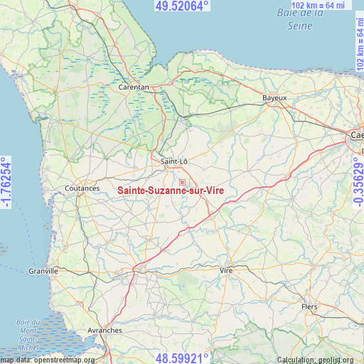
Sainte-Suzanne-sur-Vire GPS coordinates[2]
49° 3' 43.416" North, 1° 3' 33.876" West
| Map corner | latitude | longitude |
|---|---|---|
| Upper-left | 49.52064°, | -1.76254° |
| Center: | 49.06206°, | -1.05941° |
| Lower-right: | 48.59921°, | -0.35629° |
| Map W x H: | 102.5×102.5 km | = 63.7×63.7mi |
| max Lat: | 51.07786° ⇑18.8% North |
| Sainte-Suzanne-sur-Vire: | 49.06206° |
| min Lat: | ⇓81.2% South 41.3874° |
| min Long | Sainte-Suzanne- | max Long |
| -5.08615° | -1.05941° | 9.52242° |
| W 11.3%⇐ | ⇒88.7% E |
Elevation
Elevation of Sainte-Suzanne-sur-Vire is 35 m = 115 ft, and this is 158.7 m = 521 ft below average elevation for this country.
| Max E: |
2333 m = 7654 ft | 87.8% |
| Avg. | 193.7 m = 635 ft | |
| Sainte-Suzanne-sur-Vire | 35 m = 115 ft | |
Min E: |
-1 m = -3 ft | 12.2% |
See also: France elevation on elevation.city.
Geographical zone
Sainte-Suzanne-sur-Vire is located in North temperate zone (between Tropic of Cancer and the Arctic Circle). Distance of this North polar circle is 1946 km =1209.2 mi to North.| Distance of | km | miles | from Sainte-Suzanne-sur-Vire |
|---|---|---|---|
| North Pole | 4551.9 | 2828.4 | to North |
| Arctic Circle | 1946 | 1209.2 | to North |
| Tropic Cancer | 2849.3 | 1770.5 | to South |
| Equator | 5455.2 | 3389.7 | to South |


Nearby cities:
15 places around Sainte-Suzanne-sur-Vire: (largest is in red/bold)
• Agneaux
7.2 km =4.5 mi,  331°
331°
• Condé-sur-Vire
2.3 km =1.4 mi,  125°
125°
• Giéville
8 km =5 mi, 131°
• La Barre-de-Semilly
5.9 km =3.7 mi,  18°
18°
• La Mancellière-sur-Vire
1.1 km =0.7 mi,  313°
313°
• Moyon
8.1 km =5 mi,  212°
212°
• Saint-Amand
7.2 km =4.5 mi,  106°
106°
• Saint-Georges-Montcocq
7.7 km =4.8 mi,  341°
341°
• Saint-Jean-des-Baisants
7.2 km =4.5 mi,  60°
60°
• Saint-Lô
6.4 km =4 mi, 339°
• Saint-Martin-de-Bonfossé
8.1 km =5 mi,  262°
262°
• Saint-Romphaire
4.3 km =2.7 mi,  231°
231°
• Saint-Samson-de-Bonfossé
5.2 km =3.2 mi,  254°
254°
• Saint-Ébremond-de-Bonfossé
6.6 km =4.1 mi,  275°
275°
• Torigni-sur-Vire
6.3 km =3.9 mi,  116°
116°
Sources, notices
• [Note1] Compared only with cities in France existing in our database
• [Src1] Map data: © OpenStreetMap contributors (CC-BY-SA)
• [Src2] Other city data from geonames.org with taken over terms of usage.
• [Src3] Geographical zone / Annual Mean Temperature by Robert A. Rohde @ Wikipedia
