Agneaux geodata
Agneaux (Normandy) is a populated place; located in France in Europe/Paris (GMT+2) time zone. With population of 5,017 people, there are 1971 cities with bigger population in this country. Compared to other cities in France, 82.6% of cities are located further ↓South; 89.2% of cities are located further →East and 83.1% of cities have higher elevation than Agneaux. Note1
Administrative division(s):
- Level 1: Normandy
- Level 2: Manche
- Level 3: Arrondissement de Saint-Lô
- Level 4: Agneaux


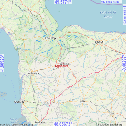
Agneaux GPS coordinates[2]
49° 7' 8.58" North, 1° 6' 21.96" West
| Map corner | latitude | longitude |
|---|---|---|
| Upper-left | 49.5771°, | -1.80923° |
| Center: | 49.11905°, | -1.1061° |
| Lower-right: | 48.65673°, | -0.40297° |
| Map W x H: | 102.3×102.3 km | = 63.6×63.6mi |
| max Lat: | 51.07786° ⇑17.4% North |
| Agneaux: | 49.11905° |
| min Lat: | ⇓82.6% South 41.3874° |
| min Long | Agneaux | max Long |
| -5.08615° | -1.1061° | 9.52242° |
| W 10.8%⇐ | ⇒89.2% E |
Elevation
Elevation of Agneaux is 47 m = 154 ft, and this is 146.7 m = 481 ft below average elevation for this country.
| Max E: |
2333 m = 7654 ft | 83.1% |
| Avg. | 193.7 m = 635 ft | |
| Agneaux | 47 m = 154 ft | |
Min E: |
-1 m = -3 ft | 16.9% |
See also: France elevation on elevation.city.
Geographical zone
Agneaux is located in North temperate zone (between Tropic of Cancer and the Arctic Circle). Distance of this North polar circle is 1939.6 km =1205.2 mi to North.| Distance of | km | miles | from Agneaux |
|---|---|---|---|
| North Pole | 4545.5 | 2824.4 | to North |
| Arctic Circle | 1939.6 | 1205.2 | to North |
| Tropic Cancer | 2855.6 | 1774.4 | to South |
| Equator | 5461.5 | 3393.6 | to South |


Nearby cities:
15 places around Agneaux: (largest is in red/bold)
• Canisy
7 km =4.3 mi,  226°
226°
• Hébécrevon
4.5 km =2.8 mi,  281°
281°
• La Barre-de-Semilly
5.3 km =3.3 mi,  98°
98°
• La Chapelle-en-Juger
8 km =5 mi, 276°
• La Mancellière-sur-Vire
6.1 km =3.8 mi,  155°
155°
• La Meauffe
6.4 km =4 mi,  356°
356°
• Pont-Hébert
5.7 km =3.5 mi,  339°
339°
• Saint-Georges-Montcocq
1.4 km =0.9 mi,  42°
42°
• Saint-Gilles
5.4 km =3.4 mi,  252°
252°
• Saint-Lô
1.2 km =0.7 mi,  105°
105°
• Saint-Martin-de-Bonfossé
8.7 km =5.4 mi,  212°
212°
• Saint-Romphaire
9 km =5.6 mi,  179°
179°
• Saint-Samson-de-Bonfossé
7.9 km =4.9 mi,  191°
191°
• Saint-Ébremond-de-Bonfossé
6.6 km =4.1 mi, 209°
• Sainte-Suzanne-sur-Vire
7.2 km =4.5 mi,  151°
151°
Sources, notices
• [Note1] Compared only with cities in France existing in our database
• [Src1] Map data: © OpenStreetMap contributors (CC-BY-SA)
• [Src2] Other city data from geonames.org with taken over terms of usage.
• [Src3] Geographical zone / Annual Mean Temperature by Robert A. Rohde @ Wikipedia
