Saint-Lyé geodata
Saint-Lyé (Grand Est) is a populated place; located in France in Europe/Paris (GMT+2) time zone. With population of 2,724 people, there are 3596 cities with bigger population in this country. Compared to other cities in France, 65.8% of cities are located further ↓South; 67.8% of cities are located further ←West and 62.4% of cities have higher elevation than Saint-Lyé. Note1
Administrative division(s):
- Level 1: Grand Est
- Level 2: Département de l'Aube
- Level 3: Arrondissement de Troyes
- Level 4: Saint-Lyé


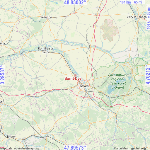
Saint-Lyé GPS coordinates[2]
48° 21' 54.072" North, 3° 59' 56.4" East
| Map corner | latitude | longitude |
|---|---|---|
| Upper-left | 48.83002°, | 3.29587° |
| Center: | 48.36502°, | 3.999° |
| Lower-right: | 47.89573°, | 4.70212° |
| Map W x H: | 103.9×103.9 km | = 64.6×64.6mi |
| max Lat: | 51.07786° ⇑34.2% North |
| Saint-Lyé: | 48.36502° |
| min Lat: | ⇓65.8% South 41.3874° |
| min Long | Saint-Lyé | max Long |
| -5.08615° | 3.999° | 9.52242° |
| W 67.8%⇐ | ⇒32.2% E |
Elevation
Elevation of Saint-Lyé is 96 m = 315 ft, and this is 97.7 m = 321 ft below average elevation for this country.
| Max E: |
2333 m = 7654 ft | 62.4% |
| Avg. | 193.7 m = 635 ft | |
| Saint-Lyé | 96 m = 315 ft | |
Min E: |
-1 m = -3 ft | 37.6% |
See also: France elevation on elevation.city.
Geographical zone
Saint-Lyé is located in North temperate zone (between Tropic of Cancer and the Arctic Circle). Distance of this North polar circle is 2023.5 km =1257.3 mi to North.| Distance of | km | miles | from Saint-Lyé |
|---|---|---|---|
| North Pole | 4629.4 | 2876.6 | to North |
| Arctic Circle | 2023.5 | 1257.3 | to North |
| Tropic Cancer | 2771.8 | 1722.3 | to South |
| Equator | 5377.7 | 3341.5 | to South |


Nearby cities:
15 places around Saint-Lyé: (largest is in red/bold)
• Barberey-Saint-Sulpice
3.8 km =2.4 mi,  139°
139°
• Fontaine-les-Grès
9.3 km =5.8 mi,  308°
308°
• La Chapelle-Saint-Luc
6.1 km =3.8 mi,  150°
150°
• La Rivière-de-Corps
8.7 km =5.4 mi,  169°
169°
• Les Noës-près-Troyes
7.6 km =4.7 mi, 153°
• Macey
10.1 km =6.3 mi,  217°
217°
• Mergey
2.3 km =1.4 mi,  17°
17°
• Payns
2.5 km =1.6 mi,  320°
320°
• Pont-Sainte-Marie
8.8 km =5.5 mi,  126°
126°
• Saint-André-les-Vergers
9.7 km =6 mi,  156°
156°
• Sainte-Maure
4.9 km =3 mi,  113°
113°
• Sainte-Savine
8.4 km =5.2 mi, 155°
• Savières
6.1 km =3.8 mi, 323°
• Torvilliers
10.3 km =6.4 mi,  190°
190°
• Troyes
9.6 km =6 mi, 138°
Sources, notices
• [Note1] Compared only with cities in France existing in our database
• [Src1] Map data: © OpenStreetMap contributors (CC-BY-SA)
• [Src2] Other city data from geonames.org with taken over terms of usage.
• [Src3] Geographical zone / Annual Mean Temperature by Robert A. Rohde @ Wikipedia
